Back جبل ليتل ارارات ARZ Kiçikağrı dağı Azerbaijani Kleiner Ararat German آرارات کوچک Persian אררט הקטן HE Սիս լեռ Armenian Pitl Ararat LLD Vesle Ararat NN Малый Арарат Russian Küçükağrı Dağı Turkish
| Little Ararat | |
|---|---|
 | |
| Highest point | |
| Elevation | 3,925 m (12,877 ft) |
| Prominence | approx. 1,200 m (4,000 ft) |
| Isolation | 8.66 km (5.38 mi) |
| Coordinates | 39°39′N 44°24′E / 39.650°N 44.400°E |
| Geography | |
| Parent range | Armenian Highlands |
| Geology | |
| Mountain type | Stratovolcano |
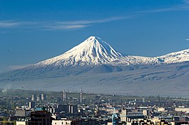
Little Ararat or Lesser Ararat (Turkish: Küçük Ağrı; Armenian: Փոքր Արարատ, romanized: Pok'r Ararat, Persian: کوه آرارات کوچک (Kuh-e Ararat-e Kuchak) Kurdish: Agiriyê Biçûk), also known as Mount Sis (Armenian: Սիս, romanized: Sis[1]), is the sixth-tallest peak and a stratovolcano in Turkey. It is a large satellite cone located on the eastern flank of the massive Mount Ararat, less than 5 mi (8.0 km) west of Turkey’s border with Iran. Despite being dwarfed by its higher and far more famous neighbor, Little Ararat is a significant volcano in its own right, with an almost perfectly symmetrical, conical form and smooth constructional slopes.[citation needed] Little Ararat rises about 1,296 m (4,252 ft) above the Serdarbulak lava plateau, which forms a saddle connecting it with the main peak.[2]
- ^ Richard G. Hovannisian (2011). The Armenian Genocide: Cultural and Ethical Legacies. Transaction Publishers. p. 113. ISBN 9781412835923.
- ^ "Mount Agri (Ararat)". anatolia.com. 2003. Retrieved 9 January 2021.
Little Mount Agri (Ararat) reaches up to 3896 meters; the Serdarbulak lava plateau (2600 m) stretches out between the two pinnacles.
