Back Lochearnhead German Lochearnhead Basque Lochearnhead French Ceann Loch Éireann Irish Ceann Loch Èire Scots/Gaelic Lochearnhead Italian Lochearnhead Dutch
Lochearnhead
| |
|---|---|
 Lochearnhead and Glen Ogle | |
Location within the Stirling council area | |
| OS grid reference | NN590235 |
| • Edinburgh | 52 mi (84 km) |
| • London | 377 mi (607 km) |
| Civil parish | |
| Council area | |
| Lieutenancy area | |
| Country | Scotland |
| Sovereign state | United Kingdom |
| Post town | LOCHEARNHEAD |
| Postcode district | FK19 |
| Dialling code | 01567 01877 |
| Police | Scotland |
| Fire | Scottish |
| Ambulance | Scottish |
| UK Parliament | |
| Scottish Parliament | |
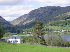
Lochearnhead (Scottish Gaelic: Ceann Loch Èireann) is a village in Perthshire on the A84 Stirling to Crianlarich road at the foot of Glen Ogle, 14 miles (23 kilometres) north of the Highland Boundary Fault. It is situated at the western end of Loch Earn where the A85 road from Crieff meets the A84.
Loch Earn is 317 feet (97 metres) above sea level, with the settlement running from its shores up to higher ground on the hills at the mouth of Glen Ogle.[1] Lochearnhead lies within the Breadalbane area of the Loch Lomond and The Trossachs National Park.
- ^ OS Landranger 51
