Back لندندري (نيوهامشير) Arabic لندندرى ARZ Лондондерри (Нью-Гэмпшир) Bashkir Londonderry (Nou Hampshire) Catalan Лондондерри (Нью-Гэмпшир) CE Londonderry (lungsod sa Tinipong Bansa) CEB Londonderry, New Hampshire Welsh Londonderry (New Hampshire) German Londonderry (Nuevo Hampshire) Spanish Londonderry (New Hampshire) Basque
Londonderry, New Hampshire | |
|---|---|
From top, left to right: Londonderry Grange #44, Mack's Apples blossoms, gun on the town common, Londonderry United Methodist Church, Mack's Apples farm market | |
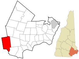
 Location in Rockingham County and the state of New Hampshire | |
| Coordinates: 42°51′54″N 71°22′26″W / 42.86500°N 71.37389°W | |
| Country | United States |
| State | New Hampshire |
| County | Rockingham |
| Incorporated | 1722 |
| Villages |
|
| Government | |
| • Town Council |
|
| • Town Manager | Michael Malaguti |
| Area | |
| • Total | 42.1 sq mi (109.1 km2) |
| • Land | 42.0 sq mi (108.8 km2) |
| • Water | 0.1 sq mi (0.3 km2) 0.30% |
| Elevation | 420 ft (130 m) |
| Population (2020) | |
| • Total | 25,826 |
| • Density | 615/sq mi (237.4/km2) |
| Time zone | UTC-5 (Eastern) |
| • Summer (DST) | UTC-4 (Eastern) |
| ZIP code | 03053 |
| Area code | 603 |
| FIPS code | 33-43220 |
| GNIS feature ID | 0873651 |
| Website | www |
Londonderry is a town in western Rockingham County, New Hampshire, United States. It sits between Manchester and Derry, the largest and fourth-largest communities in the state. The population was 25,826 at the 2020 census.[2] Londonderry is known for its apple orchards[3] and is home to the headquarters of Stonyfield Farm and part of Manchester–Boston Regional Airport.
The more densely settled portion of town, where 11,645 people lived at the 2020 census,[4] is defined as the Londonderry census-designated place (CDP) and roughly occupies the southeastern and southern parts of town, around New Hampshire Route 102.
- ^ "2021 U.S. Gazetteer Files – New Hampshire". United States Census Bureau. Retrieved December 29, 2021.
- ^ "Census - Geography Profile: Londonderry town, Rockingham County, New Hampshire". United States Census Bureau. Retrieved December 29, 2021.
- ^ Bookman, Todd (January 23, 2018). "Can You Build A Downtown From Scratch? Londonderry, N.H. Is Going To Find Out". NHPR. Retrieved November 7, 2018.
- ^ "Census - Geography Profile: Londonderry CDP, New Hampshire". United States Census Bureau. Retrieved December 24, 2021.


