| Lost Creek Lake | |
|---|---|
 The lake behind William L. Jess Dam | |
| Location | Jackson County, Oregon |
| Coordinates | 42°40′59″N 122°39′17″W / 42.68306°N 122.65472°W |
| Type | reservoir |
| Primary inflows | Rogue River |
| Primary outflows | Rogue River |
| Catchment area | 674 sq mi (1,750 km2) |
| Basin countries | United States |
| Max. length | 10 mi (16 km) |
| Surface area | 3,430 acres (13.9 km2) (full pool) |
| Water volume | 315,000 acre⋅ft (389×106 m3) |
| Shore length1 | 30 mi (48 km) |
| Surface elevation | 1,751 to 1,872 ft (534 to 571 m)[1] |
| 1 Shore length is not a well-defined measure. | |


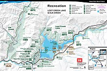
Lost Creek Lake is a reservoir located on the Rogue River in Jackson County, Oregon, United States. The lake is impounded by William L. Jess Dam which was constructed by the U.S. Army Corps of Engineers in 1977 for flood control and fisheries enhancement. The lake and dam were the first completed elements of the multi-purpose Rogue River Basin Project, consisting of Lost Creek Lake, Applegate Lake and the Elk Creek project. The lake is located approximately 27 miles (43 km) (straight line) northeast of Medford.[1]
- ^ a b "Lost Creek Dam and Lake". www.nwd-wc.usace.army.mil. Columbia Basin Water Management Division. 2009-05-31. Archived from the original on 2009-05-12. Retrieved 2009-05-10.


