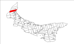
Lot 4, Prince Edward Island | |
|---|---|
Township | |
 Map of Prince Edward Island highlighting Lot 4 | |
| Coordinates: 46°48′41″N 64°9′54″W / 46.81139°N 64.16500°W | |
| Country | Canada |
| Province | Prince Edward Island |
| County | Prince County |
| Parish | Egmont Parish |
| Area | |
| • Total | 102.83 km2 (39.70 sq mi) |
| Population (2006) | |
| • Total | 1,175 |
| • Density | 11.4/km2 (30/sq mi) |
| Time zone | UTC-4 (AST) |
| • Summer (DST) | UTC-3 (ADT) |
| Canadian Postal code | C0B |
| Area code | 902 |
| NTS Map | 021I16 |
| GNBC Code | BAEQQ |
Lot 4 is a township in Prince County, Prince Edward Island, Canada created during the 1764–1766 survey of Samuel Holland. It is part of Egmont Parish.
