Back لوفينغتون (نيومكسيكو) Arabic لوفينجتون ARZ لاوینقتون، نیومکزیکو AZB Lovington (Nou Mèxic) Catalan Ловингтон (Нью-Мексико) CE Lovington (kapital sa kondado) CEB Lovington, New Mexico Welsh Lovington DAG Lovington (New Mexico) German Lovington (Nuevo México) Spanish
Lovington, New Mexico | |
|---|---|
 Lovington Public Library | |
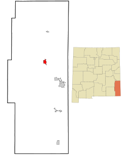
 Location of Lovington, New Mexico | |
| Coordinates: 32°57′06″N 103°20′59″W / 32.95167°N 103.34972°W | |
| Country | United States |
| State | New Mexico |
| County | Lea |
| Area | |
| • Total | 11.23 sq mi (29.10 km2) |
| • Land | 11.21 sq mi (29.03 km2) |
| • Water | 0.03 sq mi (0.07 km2) |
| Elevation | 3,918 ft (1,194 m) |
| Population | |
| • Total | 11,668 |
| • Density | 1,040.95/sq mi (401.90/km2) |
| Time zone | UTC−7 (Mountain (MST)) |
| • Summer (DST) | UTC−6 (MDT) |
| ZIP code | 88260 |
| Area code | 575 |
| FIPS code | 35-44490 |
| GNIS feature ID | 2410888[2] |
| Website | lovington |
Lovington is a city in, and the county seat of, Lea County, New Mexico, United States.[4] The population was 11,009 at the 2010 census,[5] up from 9,471 in 2000.
- ^ "ArcGIS REST Services Directory". United States Census Bureau. Retrieved October 12, 2022.
- ^ a b U.S. Geological Survey Geographic Names Information System: Lovington, New Mexico
- ^ Cite error: The named reference
USCensusDecennial2020CenPopScriptOnlywas invoked but never defined (see the help page). - ^ "Find a County". National Association of Counties. Retrieved June 7, 2011.
- ^ "Total Population: 2010 Census DEC Summary File 1 (P1), Lovington city, New Mexico". data.census.gov. U.S. Census Bureau. Retrieved May 7, 2020.