| Lunar Crater volcanic field | |
|---|---|
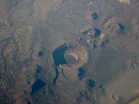
 Aerial view of Lunar Crater and surrounding vents | |
| Highest point | |
| Elevation | 2,255 m (7,398 ft)[1] |
| Coordinates | 38°N 116°W / 38°N 116°W[2] |
| Geography | |
| Geology | |
| Last eruption | 38,100 ± 10,000 years ago |
Lunar Crater volcanic field is a volcanic field in Nye County, Nevada. It lies along the Reveille and Pancake Ranges and consists of over 200 vents, mostly small volcanic cones with associated lava flows but also several maars, including one maar named Lunar Crater. Some vents have been eroded so heavily that the structures underneath the volcanoes have been exposed. Lunar Crater itself has been used as a testing ground for Mars rovers and as training ground for astronauts.
The volcanic field has formed on top of older, Oligocene to Miocene age volcanic rocks and calderas, but its own activity commenced only about 6 million years ago. The reasons for the volcanic activity there are not well known. The volcanic field has produced various types of basaltic magma and also trachyte; the most recent eruption was about 38,000 years ago and renewed activity is possible.
- ^ Cite error: The named reference
GVPwas invoked but never defined (see the help page). - ^ Valentine, Shufelt & Hintz 2011, p. 757.

