Back لوترویل، مریلند AZB Lutherville CEB Lutherville (Maryland) Basque لوترویل، مریلند Persian Lutherville Hungarian Lutherville Italian Lutherville (Maryland) LLD Lutherville Polish Lutherville, Maryland Serbo-Croatian Лутервил (Мериленд) Serbian
Lutherville, Maryland | |
|---|---|
 Lutherville light rail station platform on Ridgely Road, in Lutherville, Maryland | |
| Nickname: Old Original | |
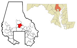
 Location of Lutherville, Maryland | |
| Coordinates: 39°25′26″N 76°37′3″W / 39.42389°N 76.61750°W | |
| Country | |
| State | |
| County | |
| Area | |
| • Total | 2.11 sq mi (5.47 km2) |
| • Land | 2.11 sq mi (5.47 km2) |
| • Water | 0.00 sq mi (0.00 km2) |
| Population (2020) | |
| • Total | 6,835 |
| • Density | 3,233.21/sq mi (1,248.54/km2) |
| Time zone | UTC−5 (Eastern (EST)) |
| • Summer (DST) | UTC−4 (EDT) |
| ZIP codes | 21093-21094 |
| Area code(s) | 410, 443 |
| FIPS code | 24-48875 |
Lutherville is a census-designated place (CDP) in Baltimore County, Maryland, United States. As of the 2010 census it had a population of 6,504.[2] Prior to 2010 the area was part of the Lutherville-Timonium CDP. Within its borders lies the Lutherville Historic District.
- ^ "2020 U.S. Gazetteer Files". United States Census Bureau. Retrieved April 26, 2022.
- ^ "Profile of General Population and Housing Characteristics: 2010 Demographic Profile Data (DP-1): Lutherville CDP, Maryland". United States Census Bureau. Retrieved February 23, 2012.