This article needs additional citations for verification. (June 2019) |
| Lyndoch South Australia | |||||||||||||||
|---|---|---|---|---|---|---|---|---|---|---|---|---|---|---|---|
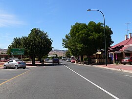
 Main street of Lyndoch | |||||||||||||||
| Coordinates | 34°36′14″S 138°53′12″E / 34.60375°S 138.886624°E[1] | ||||||||||||||
| Population | 2,000 (2016 census)[2] | ||||||||||||||
| Established | 1837 | ||||||||||||||
| Postcode(s) | 5351 | ||||||||||||||
| Elevation | 175 m (574 ft) | ||||||||||||||
| Location | 58 km (36 mi) North East of Adelaide via | ||||||||||||||
| LGA(s) | Barossa Council[1] | ||||||||||||||
| Region | Barossa Light and Lower North[1] | ||||||||||||||
| County | Adelaide[1] | ||||||||||||||
| State electorate(s) | Schubert | ||||||||||||||
| Federal division(s) | Barker | ||||||||||||||
| |||||||||||||||
Lyndoch is a town in Barossa Valley, located on the Barossa Valley Highway between Gawler and Tanunda, 58 km northeast of Adelaide. The town has an elevation of 175m and an average rainfall of 560.5mm. It is one of the oldest towns in South Australia.
The town is now primarily a service centre for the surrounding grape and wine industry and a dormitory town with a significant number of local residents commuting to the city of Adelaide each day for employment.
Lyndoch is in the Barossa Council. It is in the state electoral district of Schubert and the federal Division of Barker.
- ^ a b c d "Search results for 'Lyndoch, LOCB' with the following datasets being selected – 'NPW and Conservation Properties'. 'Suburbs and Localities', 'Government Towns', 'Counties', 'Local Government Areas','Postcodes', 'SA Government Regions', 'Gazetteer' and 'Roads'". Location SA Map Viewer. Government of South Australia. Retrieved 29 June 2019.
- ^ Australian Bureau of Statistics (27 June 2017). "Lyndoch (State Suburb)". 2016 Census QuickStats. Retrieved 4 May 2018.

