Back ماسدام ARZ Maasdam CEB Maasdam German Maasdam Finnish Maasdam French Maasdam Italian Maasdam Dutch Maasdam SCO Масдам Ukrainian Maasdam ZH-MIN-NAN
Maasdam | |
|---|---|
Village | |
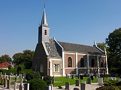
 Dutch Reformed church | |
| Coordinates: 51°47′N 4°33′E / 51.783°N 4.550°E | |
| Country | Netherlands |
| Province | South Holland |
| Municipality | Hoeksche Waard |
| Area | |
| • Total | 9.62 km2 (3.71 sq mi) |
| Elevation | −1.0 m (−3.3 ft) |
| Population (2021)[1] | |
| • Total | 3,235 |
| • Density | 340/km2 (870/sq mi) |
| Time zone | UTC+1 (CET) |
| • Summer (DST) | UTC+2 (CEST) |
| Postal code | 3299[1] |
| Dialing code | 0186 |
Maasdam is a village in the Dutch province of South Holland. It is located about 14 km south of the city of Rotterdam, in the municipality of Hoeksche Waard, on the rural Hoeksche Waard island. From the 14th Century until around 1800, Maasdam was also the name of the local administrative area, the fief and later the "ambacht".
Subsequently, from 1 January 1812 until 1 January 1984, it became the name of the local municipality, which comprised the village of Maasdam and the surrounding polders. In the periods 1812 - 1817 and 1832 - 1984, the hamlet of Cillaarshoek and the hamlet and polder of Sint Anthoniepolder were also part of the municipality of Maasdam.[3][4]
The municipality of Maasdam was eventually merged with some surrounding municipalities to become part of the new municipality of Binnenmaas. The exception was Cillaarshoek which was split and partly merged into the existing municipality of Strijen.[5] On 1 January 2019 Binnenmaas was merged with Cromstrijen, Korendijk, Oud-Beijerland, and Strijen to form the municipality of Hoeksche Waard.[6]
- ^ a b c "Kerncijfers wijken en buurten 2021". Central Bureau of Statistics. Retrieved 3 May 2022.
- ^ "Postcodetool for 3299AA". Actueel Hoogtebestand Nederland (in Dutch). Het Waterschapshuis. Retrieved 3 May 2022.
- ^ Gemeentegeschiedenis.nl, "Maasdam" [1][permanent dead link]
- ^ Hoge Raad van Adel, "Gemeente Maasdam" "Hoge Raad van Adel". Archived from the original on 18 May 2015. Retrieved 13 May 2015.
- ^ Ad van der Meer and Onno Boonstra, "Repertorium van Nederlandse gemeenten vanaf 1812", KNAW, 2nd Ed, 2011. [2]
- ^ Wet samenvoeging gemeenten Binnenmaas, Cromstrijen, Korendijk, Oud-Beijerland en Strijen, 11 July 2018, accessed at overheid.nl


