Back جسر ماكيناك Arabic كوبرى ماكيناك ARZ Mackinacbroen Danish Mackinac Bridge German Makinaca Ponto Esperanto Puente del Estrecho de Mackinac Spanish Mackinac Bridge Finnish Pont Mackinac French Mackinac Brêge Frisian Mackinac híd Hungarian
Mackinac Bridge | |
|---|---|
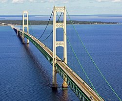
 Mackinac Bridge in June 2010 | |
| Coordinates | 45°49′01″N 84°43′40″W / 45.817059°N 84.727822°W |
| Carries | 4 lanes of |
| Crosses | Straits of Mackinac |
| Locale | St. Ignace and Mackinaw City, Michigan |
| Other name(s) | Mighty Mac or Big Mac |
| Maintained by | Mackinac Bridge Authority |
| Characteristics | |
| Design | Suspension bridge |
| Total length | 26,372 ft (8,038 m)[1] |
| Width | 68.6 ft (20.9 m) (total width)[2] 54 ft (16 m) (road width) 38.1 ft (11.6 m) (depth)[2] |
| Height | 552 ft (168 m) (tower height);[2] 200 ft (61 m) (deck height)[1] |
| Longest span | 3,800 ft (1,158 m)[2] |
| Clearance below | 155 ft (47 m)[1] |
| History | |
| Designer | David B. Steinman |
| Opened | November 1, 1957 |
| Statistics | |
| Daily traffic | 11,600 |
| Toll | $2.00 per axle for passenger vehicles ($4.00 per car). $5.00 per axle for motor homes, and commercial vehicles.[3] |
| Location | |
 | |
The Mackinac Bridge (/ˈmækənɔː/ MAK-ə-naw; also referred to as the Mighty Mac or Big Mac)[4] is a suspension bridge that connects the Upper and Lower peninsulas of the U.S. state of Michigan. It spans the Straits of Mackinac, a body of water connecting Lake Michigan and Lake Huron, two of the Great Lakes. Opened in 1957, the 26,372-foot-long (4.995 mi; 8.038 km)[1] bridge is the world's 27th-longest main span and is the longest suspension bridge between anchorages in the Western Hemisphere.[5] The Mackinac Bridge is part of Interstate 75 (I-75) and carries the Lake Michigan and Huron components of the Great Lakes Circle Tour across the straits; it is also a segment of the U.S. North Country National Scenic Trail. The bridge connects the city of St. Ignace to the north with the village of Mackinaw City to the south.
Envisioned since the 1880s, the bridge was designed by the engineer David B. Steinman and completed in 1957 only after many decades of struggles to begin construction.[6] The bridge has since become an iconic symbol of the state of Michigan.[7][8][9]
- ^ a b c d Mackinac Bridge Authority (n.d.). "Facts & Figures". Mackinac Bridge Authority. Archived from the original on January 22, 2018. Retrieved January 22, 2018.
- ^ a b c d Mackinac Straits Bridge at Structurae. Retrieved January 30, 2010.
- ^ Mackinac Bridge Authority (2010). "Mackinac Bridge Fare Schedules". Mackinac Bridge Authority. Archived from the original on December 22, 2009. Retrieved January 30, 2010.
- ^ "'Mighty Mac' Bridge Run". St. Ignace Chamber of Commerce. 2017. Retrieved September 8, 2017.
- ^ Cite error: The named reference
mba-aboutwas invoked but never defined (see the help page). - ^ Mackinac Bridge Authority (n.d.). "History of the Bridge, Mackinac Bridge". Mackinac Bridge Authority. Retrieved June 10, 2023.
- ^ Matheny, Keith (October 29, 2017). "The Mackinac Bridge turns 60 and still looks good: How long can it last?". Detroit Free Press. Retrieved March 28, 2024.
- ^ "Light The Mackinac Bridge". Mackinaw City & Mackinac Island Reviews, Comments & Attractions. Archived from the original on June 10, 2023. Retrieved June 10, 2023.
- ^ "Governor Granholm Signs Legislation Codifying Mackinac Bridge Agreement" (Press release). Office of the Governor. December 28, 2005. Retrieved March 28, 2024.