Back مقاطعة ماكوبين (إلينوي) Arabic Macoupin County, Illinois BAR Макупин (окръг, Илинойс) Bulgarian মাকৌপিন কাউন্টি, ইলিনয়স BPY Macoupin Gông (Illinois) CDO Макупин (гуо, Иллинойс) CE Macoupin County CEB Macoupin County, Illinois Welsh Macoupin County German Condado de Macoupin Spanish
Macoupin County | |
|---|---|
 Macoupin County Courthouse in Carlinville | |
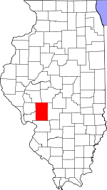
 Location within the U.S. state of Illinois | |
 Illinois's location within the U.S. | |
| Coordinates: 39°16′N 89°55′W / 39.26°N 89.92°W | |
| Country | |
| State | |
| Founded | 1829 |
| Named for | Macoupin Creek |
| Seat | Carlinville |
| Largest city | Carlinville |
| Area | |
| • Total | 868 sq mi (2,250 km2) |
| • Land | 863 sq mi (2,240 km2) |
| • Water | 4.7 sq mi (12 km2) 0.5% |
| Population (2020) | |
| • Total | 44,967 |
| • Density | 52/sq mi (20/km2) |
| Time zone | UTC−6 (Central) |
| • Summer (DST) | UTC−5 (CDT) |
| Congressional district | 13th |
| Website | www |
Macoupin County is a county located in the U.S. state of Illinois. According to the 2020 census, it had a population of 44,967.[1] The county seat is Carlinville.[2]
The primary industry is agriculture, consisting of crops of corn (maize), soybeans, and some wheat.
- ^ "Macoupin County, Illinois". United States Census Bureau. Retrieved June 10, 2023.
- ^ "Find a County". National Association of Counties. Archived from the original on May 31, 2011. Retrieved June 7, 2011.