Back Mahabubabad (Distrikt) German بخش مهابوب آباد Persian महबूबाबाद ज़िला Hindi महबूबाबाद जिल्हा Marathi महबुबाबाद जिल्ला Nepali ᱢᱚᱦᱚᱵᱩᱵᱟᱵᱟᱫᱽ ᱦᱚᱱᱚᱛ SAT மகபூபாபாத் மாவட்டம் Tamil మహబూబాబాదు జిల్లా Tegulu محبوب آباد ضلع Urdu
Mahabubabad district | |
|---|---|
 Epiphany Cathedral, Dornakal | |
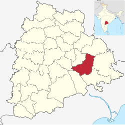
 Location in Telangana | |
| Country | India |
| State | Telangana |
| Headquarters | Mahabubabad |
| Mandalas | 16 |
| Government | |
| • District collector | Sri V.P.Goutham |
| • Parliament constituencies | Mahabubabad |
| • Assembly constituencies | Mahabubabad, Dornakal |
| Area | |
| • Total | 2,876.70 km2 (1,110.70 sq mi) |
| Population (2011) | |
| • Total | 774,549 |
| • Density | 270/km2 (700/sq mi) |
| Time zone | UTC+05:30 (IST) |
| Vehicle registration | TG–26[1] |
| Website | mahabubabad |
Mahabubabad district also known as Manukota district is a district in the Indian state of Telangana.[2] The district was carved out from the erstwhile Warangal district following the re-organisation of districts in the state in October 2016.[3] The district shares boundaries with Suryapet, Khammam, Bhadradri, Warangal, Mulugu and Jangaon districts.
- ^ "Telangana New Districts Names 2016 Pdf TS 31 Districts List". Timesalert.com. 11 October 2016. Retrieved 11 October 2016.
- ^ "Mahabubabad district" (PDF). Chief Commissioner of Land Administration. Archived from the original (PDF) on 9 September 2016. Retrieved 22 August 2016.
- ^ "Telangana: Telangana gets 21 new districts". The Times of India. 12 October 2016.
