Back Srŏk Malai CEB Malai (distrito) Spanish ស្រុកម៉ាឡៃ Cambodian Mălai (dystrykt) Polish Srŏk Malai Swedish Malaii Vietnamese 玛莱县 Chinese
Malai
ម៉ាឡៃ | |
|---|---|
| Malai District ស្រុកម៉ាឡៃ | |
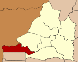
 Map showing the location of the district within Banteay Meanchey Province. | |
| Coordinates: 13°25′N 102°36′E / 13.417°N 102.600°E | |
| Country | |
| Province | Banteay Meanchey |
| Communes | 6 |
| Villages | 37 |
| Government | |
| • Governor | Tep Khunnal |
| Population (2008) | |
| • Total | 42,284 |
| Time zone | UTC+07:00 (ICT) |
| Geocode | 0109 |
Malai (Khmer: ម៉ាឡៃ [maːlaj], lit. 'The Batch of Flower') is a district (srok) in the south west of Banteay Meanchey Province, in north-western Cambodia. The district capital is the town of Malai located around 75 kilometres west of the provincial capital of Serei Saophoan by road.
The long narrow district shares a border with Thailand to the north and west and with Battambang province to the south. No national highway or national roads run through the district and road access from within Cambodia is difficult. The district was a Khmer Rouge stronghold and battleground through the 1980s and 1990s. Today it is a remote and sparsely populated border area with scattered settlements mostly made up of former rebels.[1]
Only one sizeable road in poor condition enters the district from nearby Ou Chrov district. It is 35 kilometres on this road from Malai town to the National Highway 5 near Poipet. From here, it is a further 40 kilometres to Sisophon. Malai district is one of the smallest districts in Banteay Meanchey province by land area and also has the smallest population.
Like many former Khmer Rouge held areas of the country of Democratic Kampuchea (1975-1979), infrastructure is in poor condition or is non-existent. Most of the interior of the district is uninhabited and nearly all the 37 villages in the district are located close to the border. One provincial road begins at the border and runs east through the district to an intersection near Souriya in Ou Chrov district. Numerous smaller roads also run to the Thai border along the length of the district.[2]
