Back قرية مامارونيك (نيويورك) Arabic Mamaroneck Catalan Mamaroneck (villa) Spanish Mamaroneck (village, New York) French Mamaroneck (vohitra), New York Malagasy Mamaroneck (hrabstwo Westchester) Polish Mamaroneck (village), New York SIMPLE Мемаронек (селище, Нью-Йорк) Ukrainian
Mamaroneck, New York | |
|---|---|
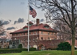
 Village Municipal Building | |
| Nickname: The Friendly Village | |
 Location of Mamaroneck (village), New York | |
| Coordinates: 40°56′57″N 73°44′1″W / 40.94917°N 73.73361°W | |
| Country | United States |
| State | New York |
| County | Westchester |
| Town | Mamaroneck, Rye (Rye Neck) |
| Area | |
| • Total | 6.62 sq mi (17.13 km2) |
| • Land | 3.21 sq mi (8.31 km2) |
| • Water | 3.41 sq mi (8.82 km2) |
| Elevation | 0 ft (0 m) |
| Population (2020) | |
| • Total | 20,151 |
| • Density | 6,279.53/sq mi (2,424.44/km2) |
| Time zone | UTC-5 (Eastern (EST)) |
| • Summer (DST) | UTC-4 (EDT) |
| ZIP code | 10543 |
| Area code | 914 |
| FIPS code | 36-44831 |
| GNIS feature ID | 0977362 |
Mamaroneck /məˈmærənɛk/ mə-MAIR-ə-nek is a village in Westchester County, New York, United States. The population was 18,929 at the 2010 census.[2] As of 2019[update], its population was an estimated 19,131.[3] It is located partially within the town of Mamaroneck and partially within the town of Rye. The portion in Rye is unofficially called "Rye Neck". The Rye Neck Union Free School District contains the Rye Neck portion of Mamaroneck and part of the city of Rye.[4]
- ^ "ArcGIS REST Services Directory". United States Census Bureau. Retrieved September 20, 2022.
- ^ "Profile of General Population and Housing Characteristics: 2010 Demographic Profile Data (DP-1): Mamaroneck village, New York". United States Census Bureau. Retrieved November 18, 2011.
- ^ "U.S. Census Bureau QuickFacts: Mamaroneck village, New York". www.census.gov. Retrieved February 1, 2020.
- ^ "Rye Neck School District". www.ryeneck.k12.ny.us. Retrieved September 17, 2021.
