Back Manning ATJ Manning (lungsod sa Kanada) CEB Manning (Alberta) German Manning (Alberta) French Manning (Canada) Italian Manning Kurdish Manning (Canada) Dutch Менинг (Алберта) Serbian Manning, Alberta Swedish Меннінг (Альберта) Ukrainian
Manning | |
|---|---|
Town | |
| Town of Manning | |
 | |
| Nickname: Land of the Mighty Moose | |
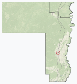
 Location in County of Northern Lights | |
| Coordinates: 56°54′51″N 117°37′38″W / 56.91417°N 117.62722°W | |
| Country | Canada |
| Province | Alberta |
| Region | Northern Alberta |
| Planning region | Lower Peace |
| Municipal district | County of Northern Lights |
| Incorporated[1] | |
| • Village | December 31, 1951 |
| • Town | January 1, 1957 |
| Government | |
| • Mayor | Robert McLeod |
| • Governing body | Manning Town Council |
| Area (2021)[3] | |
| • Land | 3.71 km2 (1.43 sq mi) |
| Elevation | 465 m (1,526 ft) |
| Population | |
| • Total | 1,126 |
| • Density | 303.1/km2 (785/sq mi) |
| Time zone | UTC−7 (MST) |
| • Summer (DST) | UTC−6 (MDT) |
| Postal code | T0H 2M0 |
| Area code | -1+780 |
| Highways | Highway 35 Highway 691 |
| Waterway | Notikewin River |
| Website | Official website |
Manning is a town in northern Alberta, Canada. It is known as the "Land of the Mighty Moose". It is located on Highway 35 on the Notikewin River, approximately 73 km (45 mi) north of Peace River.
Manning is a service centre for the local agriculture, forestry and gas industries. It also serves the nearby rural area within the County of Northern Lights including Deadwood, Hotchkiss, North Star and Notikewin.
- ^ "Location and History Profile: Town of Manning" (PDF). Alberta Municipal Affairs. October 7, 2016. p. 379. Retrieved October 16, 2016.
- ^ "Municipal Officials Search". Alberta Municipal Affairs. 2019-05-09. Retrieved 2021-10-01.
- ^ a b Cite error: The named reference
2021censuswas invoked but never defined (see the help page). - ^ "Alberta Private Sewage Systems 2009 Standard of Practice Handbook: Appendix A.3 Alberta Design Data (A.3.A. Alberta Climate Design Data by Town)" (PDF) (PDF). Safety Codes Council. January 2012. pp. 212–215 (PDF pages 226–229). Retrieved October 8, 2013.
- ^ "Population and dwelling counts: Canada and population centres". Statistics Canada. February 9, 2022. Retrieved February 13, 2022.

