Back মার্কেট BPY Marker (Noruega) Catalan Marker CEB Marker Danish Marker (Norwegen) German Marker Esperanto Marker (Østfold) Spanish Markeri vald Estonian Marker Basque Marker (Norja) Finnish
Marker Municipality
Marker kommune | |
|---|---|
 | |
 Østfold within Norway | |
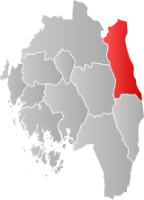
 Marker within Østfold | |
| Coordinates: 59°30′40″N 11°37′42″E / 59.51111°N 11.62833°E | |
| Country | Norway |
| County | Østfold |
| District | Smaalenene |
| Administrative centre | Ørje |
| Government | |
| • Mayor (2003) | Kjersti Nythe Nilsen (Ap) |
| Area | |
| • Total | 413 km2 (159 sq mi) |
| • Land | 368 km2 (142 sq mi) |
| • Rank | #235 in Norway |
| Population (2004) | |
| • Total | 3,409 |
| • Rank | #250 in Norway |
| • Density | 9/km2 (20/sq mi) |
| • Change (10 years) | |
| Demonym | Marking[1] |
| Official language | |
| • Norwegian form | Bokmål |
| Time zone | UTC+01:00 (CET) |
| • Summer (DST) | UTC+02:00 (CEST) |
| ISO 3166 code | NO-3122[3] |
| Website | Official website |
Marker is a municipality in Østfold county, Norway. The administrative centre of the municipality is the village of Ørje. Marker was created as a new municipality on 1 January 1964 following the merger of the two former municipalities of Rødenes and Øymark.
The municipality borders Sweden, Aurskog-Høland municipality in Akershus county, and Aremark, Eidsberg, Rakkestad, and Rømskog municipalities in Østfold county. European route E18 passes through the municipality.
The municipality's biggest attractions are the fortresses at Basmo and Ørje. Basmo Fortress lies on an isolated mountain outcrop between lakes Rødenessjøen and Hemnessjøen in the northwestern part of the municipality.
- ^ "Navn på steder og personer: Innbyggjarnamn" (in Norwegian). Språkrådet.
- ^ "Forskrift om målvedtak i kommunar og fylkeskommunar" (in Norwegian). Lovdata.no.
- ^ Bolstad, Erik; Thorsnæs, Geir, eds. (2023-01-26). "Kommunenummer". Store norske leksikon (in Norwegian). Kunnskapsforlaget.

