Back مریهیل، واشینقتون AZB Меригилл (Вашингтон) CE Maryhill (Washington) Spanish Maryhill (Washington) Basque مریهیل، واشینگتن Persian Maryhill (Washington) Frisian Maryhill (Washington) Hungarian Maryhill (Stati Uniti d'America) Italian Maryhill (Washington) LLD Maryhill Dutch
Maryhill, Washington | |
|---|---|
 Maryhill from the Stonehenge replica | |
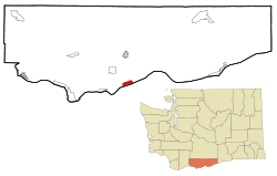
 Location of Maryhill in Klickitat County, Washington | |
| Coordinates: 45°41′8″N 120°49′2″W / 45.68556°N 120.81722°W | |
| Country | United States |
| State | Washington |
| County | Klickitat |
| Area | |
| • Total | 2.8 sq mi (7.3 km2) |
| • Land | 2.8 sq mi (7.3 km2) |
| • Water | 0.0 sq mi (0.0 km2) |
| Elevation | 187 ft (57 m) |
| Population (2020) | |
| • Total | 55 |
| • Density | 20/sq mi (7.5/km2) |
| Time zone | UTC-8 (Pacific (PST)) |
| • Summer (DST) | UTC-7 (PDT) |
| ZIP code | 98620 |
| Area code | 509 |
| FIPS code | 53-43885[1] |
| GNIS feature ID | 1522785[2] |
Maryhill from the Stonehenge replica location, but in 1913
|
Maryhill is an unincorporated community and census-designated place (CDP) in Klickitat County, Washington, United States. The population was 55 at the 2020 census.
