Back Mawrth Vallis Catalan Mawrth Vallis Welsh Mawrth Vallis German Mawrth Vallis Spanish Mawrth Vallis French Mawrth Vallis Hungarian Mawrth Vallis Italian Mawrth Vallis Portuguese Долина Маврт Russian Долина Маврт Ukrainian
 | |
| Coordinates | 22°36′N 16°30′W / 22.6°N 16.5°W |
|---|---|
| Length | 636.0 km |
| Naming | Welsh word for "Mars". |
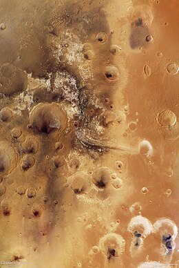
Mawrth Vallis (Welsh: [maurθ]) (Mawrth means "Mars" in Welsh) is a valley on Mars, located in the Oxia Palus quadrangle at 22.3°N, 343.5°E with an elevation approximately two kilometers below datum. Situated between the southern highlands and northern lowlands, the valley is a channel formed by massive flooding which occurred in Mars’ ancient past.[1] It is an ancient water outflow channel with light-colored clay-rich rocks.
Prior to the selection of Gale Crater for the Mars Science Laboratory (MSL) Curiosity rover mission, Mawrth Vallis was considered as a potential landing site because of the detection of a stratigraphic section rich in clay minerals. Clay minerals have implications for past aqueous environments as well as the potential to preserve biosignatures, making them ideal targets for the search for life on Mars.[2] Although Mawrth Vallis was not chosen as a landing target, there is still interest in understanding the mineralogy and stratigraphy of the area. Until a rover mission is committed to exploring Mawrth Vallis, orbiters remain the only source of information. These orbiters consist of a number of spectrometers that contribute to our knowledge of Mawrth Vallis and the rest of the Martian surface.
- ^ "Possible MSL Landing Site: Mawrth Vallis". Archived from the original on 2009-04-18.
- ^ Michalski, JR; Bibring J-P; Poulet F; Loizeau D; Mangold N; Dobrea EN; Bishop JL; Wray JJ; McKeown NK; Parente M; Hauber E; Altieri F; Carrozzo FG; Niles PB (September 2010). "The Mawrth Vallis region of Mars: A potential landing site for the Mars Science Laboratory (MSL) mission". Astrobiology. 10 (7): 687–703. Bibcode:2010AsBio..10..687M. doi:10.1089/ast.2010.0491. PMID 20950170.