Back مايبروك (نيويورك) Arabic Maybrook CEB Maybrook, Efrog Newydd Welsh Maybrook Spanish Maybrook (New York) Basque Maybrook (New York) French Maybrook, New York HT Maybrook Italian Maybrook (New York) LLD Maybrook Polish
Maybrook | |
|---|---|
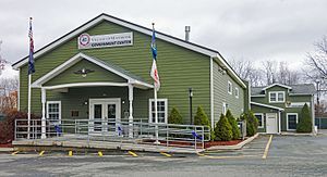
 Maybrook village hall in 2015 | |
 Location of Orange County, New York (left) and of Maybrook in Orange County (right) | |
 Location of New York state in the United States | |
| Coordinates: 41°29′21″N 74°12′48″W / 41.48917°N 74.21333°W | |
| Country | United States |
| State | New York |
| County | Orange |
| Founded | 1926 |
| Government | |
| • Mayor | Dennis K. Leahy (D) |
| Area | |
| • Total | 1.36 sq mi (3.52 km2) |
| • Land | 1.35 sq mi (3.51 km2) |
| • Water | 0.01 sq mi (0.01 km2) |
| Elevation | 420 ft (130 m) |
| Highest elevation (Unnamed hill near west village line) | 520 ft (160 m) |
| Lowest elevation (Swampy area in northeast corner) | 360 ft (110 m) |
| Population (2020) | |
| • Total | 3,150 |
| • Density | 2,326.44/sq mi (898.09/km2) |
| Time zone | UTC-5 (Eastern (EST)) |
| • Summer (DST) | UTC-4 (EDT) |
| ZIP Code | 12543 |
| Area code | 845 |
| FIPS code | 36-46162 |
| GNIS feature ID | 0956701 |
| Wikimedia Commons | Maybrook, New York |
| Website | villageofmaybrook |
Maybrook is a village in Orange County, New York, United States. The population was 3,150 at the 2020 census. It is part of the Poughkeepsie–Newburgh–Middletown, NY Metropolitan Statistical Area as well as the larger New York–Newark–Bridgeport, NY-NJ-CT-PA Combined Statistical Area.
It is located mostly in the town of Montgomery, but a small portion is in the town of Hamptonburgh. It is also defined by the 427 telephone exchange in the 845 area code and the 12543 ZIP code, as well as its own eponymous fire district.
- ^ "ArcGIS REST Services Directory". United States Census Bureau. Retrieved September 20, 2022.