Back Mbarali district CEB Mbarali (Distrikt) German Περιοχή Μπαράλι Greek Distretto di Mbarali Italian Mbarali Swahili Mbarali (huyện) Vietnamese Mbarali District Zulu
Mbarali | |
|---|---|
 Mbarali District of Mbeya Region | |
| Coordinates: 08°04′S 34°38′E / 8.067°S 34.633°E | |
| Country | |
| Region | Mbeya Region |
| District | Mbarali District |
| Headquarters | Rujewa |
| Government | |
| • Type | Council |
| • Chairman[1] | Twalib Tamimu Lubandamo |
| • Director[1] | Missana Kalela Kwangura |
| Area | |
| • Total | 14,438 km2 (5,575 sq mi) |
| Population (2022) | |
| • Total | 446,336 |
| • Density | 31/km2 (80/sq mi) |
| • Religion | Christianity |
| Time zone | EAT |
| Postcode[2] | 536xx |
| Area code | 025 |
| Website | District Website |
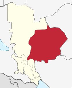
Mbarali District is one of the five districts of Mbeya Region, Tanzania. It is bordered to the north by Iringa region and east by Njombe region. To the south the district is bordered by Mbeya District and to the west by Chunya District.
In 2016 the Tanzania National Bureau of Statistics report there were 331,206 people in the district, from 300,517 in 2012.[3]: 97 [4]: 118
Mbarali district is the most famous area for rice farming. The district is home to Kapunga rice project and Mbarali estate. The district hosts a very famous wetland called Ihefu, as well as the Usangu plain. Ruaha National Park is within the district to the north side.
- ^ a b Cite error: The named reference
MbaraliDCwas invoked but never defined (see the help page). - ^ Cite error: The named reference
Mbeya_postcodewas invoked but never defined (see the help page). - ^ Cite error: The named reference
2016_censuswas invoked but never defined (see the help page). - ^ Cite error: The named reference
2012_censuswas invoked but never defined (see the help page).