Back مقاطعة ماكلين (داكوتا الشمالية) Arabic McLean County, North Dakota BAR Маклийн (окръг, Северна Дакота) Bulgarian ম্যাকলিন কাউন্টি, নর্থ ডাকোটা BPY McLean Gông (North Dakota) CDO McLean County (kondado sa Tinipong Bansa, North Dakota) CEB McLean County, Gogledd Dakota Welsh McLean County (North Dakota) German Κομητεία ΜακΛίν (Βόρεια Ντακότα) Greek Condado de McLean (Dakota del Norte) Spanish
McLean County | |
|---|---|
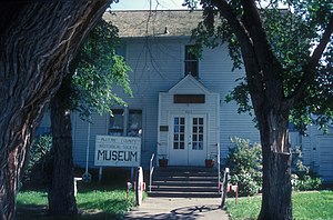
 Historic McLean County Courthouse, now Historical Museum. | |
 Location within the U.S. state of North Dakota | |
 North Dakota's location within the U.S. | |
| Coordinates: 47°37′N 101°19′W / 47.61°N 101.32°W | |
| Country | |
| State | |
| Founded | March 8, 1883 (created) November 1, 1883 (organized) |
| Named for | John A. McLean |
| Seat | Washburn |
| Largest city | Garrison |
| Area | |
• Total | 2,328 sq mi (6,030 km2) |
| • Land | 2,111 sq mi (5,470 km2) |
| • Water | 217 sq mi (560 km2) 9.3% |
| Population (2020) | |
• Total | 9,771 |
• Estimate (2023) | 9,832 |
| • Density | 4.2/sq mi (1.6/km2) |
| Time zone | UTC−6 (Central) |
| • Summer (DST) | UTC−5 (CDT) |
| Congressional district | At-large |
| Website | www |
McLean County (/məˈkleɪn/ mə-KLAYN) is a county in the U.S. state of North Dakota. As of the 2020 census, the population was 9,771.[1] Its county seat is Washburn.[2]
- ^ "State & County QuickFacts". United States Census Bureau. Retrieved May 9, 2024.
- ^ "Find a County". National Association of Counties. Archived from the original on May 31, 2011. Retrieved June 7, 2011.