Back مقاطعة ميرسر (فرجينيا الغربية) Arabic Mercer County, West Virginia BAR Мърсър (окръг, Западна Вирджиния) Bulgarian মারর্সের কাউন্টি, ৱেস্ট ভার্জিনিয়া BPY Mercer Gông (West Virginia) CDO Мерсер (гуо, Малхбузен Виргини) CE Mercer County (kondado sa Tinipong Bansa, West Virginia) CEB Mercer County, Gorllewin Virginia Welsh Mercer County (West Virginia) German Kantono Mercer (Okcidenta Virginio) Esperanto
Mercer County | |
|---|---|
 The Mercer County Courthouse in Princeton in 2007 | |
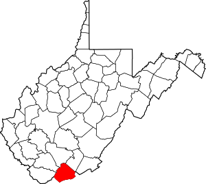
 Location within the U.S. state of West Virginia | |
 West Virginia's location within the U.S. | |
| Coordinates: 37°25′N 81°07′W / 37.41°N 81.11°W | |
| Country | |
| State | |
| Founded | March 17, 1837 |
| Seat | Princeton |
| Largest town | Bluefield |
| Area | |
| • Total | 421 sq mi (1,090 km2) |
| • Land | 419 sq mi (1,090 km2) |
| • Water | 1.7 sq mi (4 km2) 0.4% |
| Population (2020) | |
| • Total | 59,664 |
| • Estimate (2021) | 59,097 |
| • Density | 140/sq mi (55/km2) |
| Time zone | UTC−5 (Eastern) |
| • Summer (DST) | UTC−4 (EDT) |
| Congressional district | 1st |
| Website | www |
Mercer County is a county in Southern West Virginia on the southeastern border of the U.S. state of West Virginia. At the 2020 census, the population was 59,664.[1] Its county seat is Princeton.[2] The county was originally established in the State of Virginia by act of its General Assembly on March 17, 1837,[3][4] using lands taken from Giles and Tazewell counties.
Mercer County is part of the Bluefield, WV-VA Micropolitan Statistical Area.
- ^ "State & County QuickFacts". United States Census Bureau. Retrieved July 7, 2022.
- ^ "Find a County". National Association of Counties. Retrieved June 7, 2011.
- ^ "West Virginia Counties". West Virginia Division of Culture and History. Archived from the original on September 23, 2001. Retrieved February 24, 2014. (WV County Etymology)
- ^ "West Virginia Counties". Archived from the original on September 23, 2001. Retrieved July 23, 2013.

