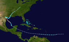
 Map plotting the track and intensity of Hurricane Harvey according to the Saffir–Simpson scale | |
| Meteorological history | |
|---|---|
| Formed | August 17, 2017 |
| Extratropical | September 1, 2017 |
| Dissipated | September 2, 2017 |
| Category 4 major hurricane | |
| 1-minute sustained (SSHWS/NWS) | |
| Highest winds | 130 mph (215 km/h) |
| Lowest pressure | 937 mbar (hPa); 27.67 inHg |
| Overall effects | |
| Areas affected | Windward Islands, Suriname, Guyana, Nicaragua, Honduras, Belize, Yucatán Peninsula, United States (particularly Texas) |
Part of the 2017 Atlantic hurricane season | |
| History • Meteorological history Effects • Commons: Harvey images | |
Hurricane Harvey was the costliest tropical cyclone on record (tied with Hurricane Katrina of 2005), inflicting roughly $125 billion in damage across the Houston metropolitan area and Southeast Texas.[1] It lasted from mid-August until early September 2017, with many records for rainfall and landfall intensity set during that time. The eighth named storm, third hurricane, and first major hurricane of the 2017 Atlantic hurricane season, Harvey originated from a broad area of low pressure southwest of Cape Verde that was first monitored on August 13. Tracking steadily westward, the disturbance developed strong convection, a well-defined circulation, and sustained tropical storm-force winds, leading to the classification of Tropical Storm Harvey late on August 17. Moderate easterly vertical wind shear kept Harvey weak, as it continued westwards into the Caribbean Sea; despite repeated predictions for gradual intensification by the National Hurricane Center, Harvey eventually opened up into a tropical wave on August 19. The remnants of Harvey continued to move westwards and reached the Yucatán Peninsula on August 22, and were forecast to regenerate into a tropical cyclone after exiting land.
On August 23, Harvey moved into the Bay of Campeche and quickly developed a well-defined circulation, becoming a tropical depression later that day and a tropical storm fifteen hours later. Curving northwestwards into a favorable environment with low wind shear and high sea surface temperatures, Harvey began to consolidate and developed an eye. Rapid intensification ensued as Harvey approached the coast of Texas, with Harvey becoming a hurricane in the afternoon of August 24. Despite some dry air entrainment halting the intensification process for the rest of the day, Harvey soon resumed strengthening and became the season's first major hurricane in the evening of August 25. Continuing to deepen, Harvey attained peak intensity with maximum sustained winds of 215 kilometres per hour (130 mph)—Category 4 status on the Saffir–Simpson scale—and a minimum pressure of 937 mbar (27.67 inHg), as it made its first landfall near Rockport, Texas at 03:00 UTC on August 26. This made Harvey the first major hurricane to make landfall in the United States since Wilma in 2005, the first major hurricane in Texas since Bret in 1999, and the strongest in Texas since Carla in 1961. Rapid weakening began as Harvey made a second landfall just north of Holiday Beach three hours after its first, degrading to a tropical storm that evening. Trapped between two ridges to its west and east, Harvey dramatically slowed as it moved inland, but began drifting southeast back towards water on August 27.
Harvey reemerged over the extreme western Gulf of Mexico as a weak tropical storm early on August 28; by this time almost 30 in (760 mm) of rain had fallen in the Greater Houston area. Moving slowly east-southeastwards, Harvey would bring an additional 20 in (510 mm) of rain to Greater Houston and parts of southwestern Louisiana over the next three days, becoming the wettest tropical cyclone on record in the United States. Eventually, a trough moving over the Ohio Valley pulled Harvey northwards, and Harvey made a third and final landfall just west of Cameron, Louisiana, on August 30 before weakening into a tropical depression. Continuing to push inland, Harvey gradually lost tropical characteristics and transitioned into an extratropical cyclone on September 1.
- ^ Costliest U.S. tropical cyclones tables updated (PDF) (Report). Miami, Florida: National Hurricane Center. January 26, 2018. Retrieved July 2, 2019.
