Back فانكوفر الكبرى (كولومبيا البريطانية) Arabic Metro Vancouver Electoral Area A German Greater Vancouver A Spanish 大溫哥華地區A選區 Chinese
Electoral Area A | |
|---|---|
| Metro Vancouver Electoral Area A | |
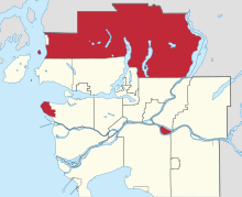
 Location of Electoral Area A in Metro Vancouver | |
| Country | Canada |
| Province | British Columbia |
| Regional district | Metro Vancouver |
| Regional district office | Metrotower III[1] |
| Government | |
| • Director | Jen McCutcheon |
| Area | |
| • Land | 815.21 km2 (314.75 sq mi) |
| • Urban | 14.49 km2 (5.59 sq mi) |
| • Rural | 800.72 km2 (309.16 sq mi) |
| [Note 1] | |
| Population (2021)[3] | |
| • Regional district electoral area | 18,612 |
| • Density | 22.8/km2 (59/sq mi) |
| • Urban | 18,296 |
| • Urban density | 1,300/km2 (3,300/sq mi) |
| • Rural | 316 |
| • Rural density | 0.39/km2 (1.0/sq mi) |
| Time zone | UTC-8 (Pacific Standard Time) |
| • Summer (DST) | UTC-7 (Pacific Daylight Time) |
| Area codes | 604, 778, 236, 672 |
Metro Vancouver Electoral Area A is a part of Metro Vancouver in British Columbia. It includes several unincorporated areas: the University Endowment Lands and the University of British Columbia, west of the City of Vancouver; Bowyer, Passage, and Barnston Islands; the west side of Pitt Lake; the northern portion of Indian Arm; and a large area to the north of the North Shore that is mostly mountainous and sparsely populated except for certain subdivisions between Horseshoe Bay and the Village of Lions Bay.
The Electoral Area is represented by a director on the board of the regional district. This is an elected position, with a four-year term. The current director is Jen McCutcheon.[2]
- ^ "Metro Vancouver Board of Directors - Contact Information" (PDF). Metro Vancouver Regional District. February 28, 2022. Retrieved August 9, 2022.
- ^ a b "Board Members". Metro Vancouver. Retrieved May 14, 2015.
- ^ a b Government of Canada, Statistics Canada (2022-02-09). "Profile table, Census Profile, 2021 Census of Population - Metro Vancouver A, Regional district electoral area (RDA) [Census subdivision], British Columbia". www12.statcan.gc.ca. Retrieved 2022-08-10.
- ^ "Urban Containment". www.metrovancouver.org. Retrieved 2022-08-10.
- ^ a b "About Electoral Area A". www.metrovancouver.org. Retrieved 2022-08-10.
Cite error: There are <ref group=Note> tags on this page, but the references will not show without a {{reflist|group=Note}} template (see the help page).