| Middle Fork Feather River El Rio de las Plumas[1] | |
|---|---|
 The Middle Fork near Red Bridge Campground, May 2022 | |
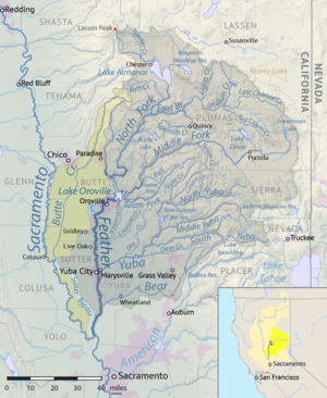
 Map of the Feather River watershed including the Middle Fork Feather | |
| Etymology | "Plumas" means "feather" in Spanish |
| Location | |
| Country | United States |
| State | California |
| Region | Sierra Nevada |
| Cities | Beckwourth, Portola, Cromberg, Graeagle |
| Physical characteristics | |
| Source | Near Beckwourth |
| • location | Sierra Valley, Plumas County |
| • coordinates | 39°48′49″N 120°22′46″W / 39.81361°N 120.37944°W[1] |
| • elevation | 4,872 ft (1,485 m)[2] |
| Mouth | Lake Oroville |
• location | About 10 miles (16 km) northeast of Oroville, Butte County |
• coordinates | 39°38′29″N 121°17′11″W / 39.64139°N 121.28639°W[1] |
• elevation | 928 ft (283 m)[1] |
| Length | 98 mi (158 km), East-west |
| Basin size | 1,062 sq mi (2,750 km2)[3] |
| Discharge | |
| • location | Merrimac[3] |
| • average | 1,489.5 cu ft/s (42.18 m3/s)[3] |
| • maximum | 86,200 cu ft/s (2,440 m3/s)[4] |
| Basin features | |
| River system | Feather River watershed |
| Tributaries | |
| • left | Sulphur Creek, Frazier Creek, Gray Eagle Creek, Jamison Creek, Nelson Creek, Onion Valley Creek, South Branch Middle Fork Feather River, Fall River |
| • right | Little Last Chance Creek, Big Grizzly Creek, Bear Creek, North Fork Middle Fork Feather River |
The Middle Fork Feather River is a major river in Plumas and Butte Counties in the U.S. state of California.[1] Nearly 100 miles (160 km) long, it drains about 1,062 square miles (2,750 km2)[3] of the rugged northern Sierra Nevada range.[5]
- ^ a b c d e "Middle Fork Feather River". Geographic Names Information System. United States Geological Survey, United States Department of the Interior. 1981-01-19. Retrieved 2010-09-16. NOTE For the coordinates of the Middle Fork's mouth, the USGS's National Elevation Database lists a different elevation (902.7 ft):
- "Elevation query for "X_Value=-121.2807956&Y_Value=39.6376648" (returns "902.739597430692 … FEET")". USGS Elevation Query Web Service. Retrieved 2010-09-25.
- ^ "North Channel Little Last Chance Creek". Geographic Names Information System. United States Geological Survey, United States Department of the Interior. 1981-01-19. Retrieved 2010-09-16.
- ^ a b c d "USGS Gage #11394500 on the Middle Fork Feather River near Merrimac, CA (Monthly Average Streamflow)". National Water Information System. U.S. Geological Survey. 1951–1986. Retrieved 2010-09-16.
- ^ "USGS Gage #11394500 on the Middle Fork Feather River near Merrimac, CA (Peak Streamflow)". National Water Information System. U.S. Geological Survey. 1951–1986. Retrieved 2010-09-16.
- ^ George, Holly; et al. (March 2007). "Upper Feather River Watershed (UFRW) Irrigation Discharge Management Program" (PDF). State Water Resources Control Board. University of California Davis. Archived from the original (PDF) on 2010-06-12. Retrieved 2010-09-16.
