Back Millicent Catalan Millicent CEB میلیسنت، استرالیای جنوبی Persian Millicent French Millicent (Australia) Italian ミリセント Japanese Millicent Polish Millicent Portuguese Millicent Swedish
This article needs additional citations for verification. (September 2016) |
| Millicent South Australia | |||||||||||||||
|---|---|---|---|---|---|---|---|---|---|---|---|---|---|---|---|
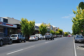
 Main street | |||||||||||||||
| Coordinates | 37°35′48″S 140°21′09″E / 37.596737°S 140.352369°E[1] | ||||||||||||||
| Population | 4,760 (UCL 2021)[2] | ||||||||||||||
| Postcode(s) | 5280 | ||||||||||||||
| Elevation | 19 m (62 ft)[3] | ||||||||||||||
| Time zone | ACST (UTC+9:30) | ||||||||||||||
| • Summer (DST) | ACST (UTC) | ||||||||||||||
| Location |
| ||||||||||||||
| LGA(s) | Wattle Range Council | ||||||||||||||
| Region | Limestone Coast[1] | ||||||||||||||
| County | Grey[1] | ||||||||||||||
| State electorate(s) | MacKillop[4] | ||||||||||||||
| Federal division(s) | Barker[5] | ||||||||||||||
| |||||||||||||||
| |||||||||||||||
| Footnotes | Adjoining localities[1] | ||||||||||||||
Millicent is a town in the Australian state of South Australia located about 399 kilometres (248 mi) south-east of the state capital of Adelaide and about 50 kilometres (31 mi) north of the regional centre of Mount Gambier. In the 2021 census, the population was 4,760.[7]
The town is home to the Millicent National Trust Museum, Millicent Library & Gallery, Millicent Civic & Arts Centre, the South East Family History Group, and more attractions where locals commonly go to. Millicent is also nearby to the Tantanoola Caves Conservation Park and the Canunda National Park.
Close by is Lake Bonney SE which is home to South Australia's largest wind turbine farm. Millicent is also home to a constructed lake, Lake McIntyre, home to many bird and wildlife species. Lake McIntyre takes approximately 20 minutes to walk around, and the lake also hosts over 50 species of water birds and waders.[8]
- ^ a b c d "Search results for "Millicent, LOCB" with the following datasets selected – 'Suburbs and Localities', 'Counties', "Government Towns", 'Hundreds', 'Local Government Areas', 'SA Government Regions' and 'Gazetter'". Location SA Map Viewer. Government of South Australia. Retrieved 25 November 2018.
- ^ Australian Bureau of Statistics (28 June 2022). "Millicent (urban centre and locality)". Australian Census 2021.
- ^ "Search results for "Millicent Railway Station, RSTA" with the following datasets selected – 'Suburbs and Localities', 'Gazetter' and 'Railways'". Location SA Map Viewer. Government of South Australia. Retrieved 24 November 2018.
- ^ "District of MacKillop Background Profile". Electoral Commission SA. Retrieved 29 March 2016.
- ^ "Federal electoral division of Barker" (PDF). Australian Electoral Commission. Retrieved 28 March 2016.
- ^ a b c "Monthly climate statistics: Summary statistics Mount Gambier Aero (nearest weather station)". Commonwealth of Australia , Bureau of Meteorology. Retrieved 24 August 2016.
- ^ Australian Bureau of Statistics (28 June 2022). "Millicent". 2021 Census QuickStats. Retrieved 28 February 2008.
- ^ "Lake McIntyre". 20 May 2021.
