Back Minchinbury Park CEB مینچینبری، نیوساوت ولز Persian Minchinbury (New South Wales) NB Minchinbury, New South Wales Romanian
| Minchinbury Sydney, New South Wales | |||||||||||||||
|---|---|---|---|---|---|---|---|---|---|---|---|---|---|---|---|
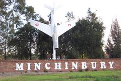
 The Jet at Minchinbury | |||||||||||||||
 | |||||||||||||||
| Population | 5,778 (2021 census)[1] | ||||||||||||||
| Postcode(s) | 2770 | ||||||||||||||
| Elevation | 57 m (187 ft) | ||||||||||||||
| Location | 38 km (24 mi) west of Sydney | ||||||||||||||
| LGA(s) | City of Blacktown | ||||||||||||||
| State electorate(s) | Mount Druitt | ||||||||||||||
| Federal division(s) | McMahon | ||||||||||||||
| |||||||||||||||
Minchinbury is a small suburb in western Sydney, in the state of New South Wales, Australia. Minchinbury is located 38 kilometres (24 mi) west of the Sydney central business district, in Blacktown local government area and is part of the Greater Western Sydney region.
Minchinbury is predominantly a residential area with a small commercial/retail area in the centre and industrial/commercial zones in the westernmost part.[2]
- ^ Australian Bureau of Statistics (28 June 2022). "Minchinbury (State Suburb)". 2021 Census QuickStats. Retrieved 25 September 2024.
- ^ "Suburb Profiles". Archived from the original on 26 August 2006. Retrieved 26 August 2006. The 2001 City of Blacktown Social Plan