| Minneopa State Park | |
|---|---|
 Upper and Lower Minneopa Falls | |
| Location | Blue Earth, Minnesota, United States |
| Coordinates | 44°9′44″N 94°6′8″W / 44.16222°N 94.10222°W |
| Area | 4,643 acres (18.79 km2) |
| Elevation | 856 ft (261 m)[1] |
| Established | 1905 |
| Governing body | Minnesota Department of Natural Resources |
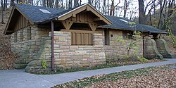
Minneopa State Park WPA/Rustic Style Historic Resources | |
 A WPA/Rustic Style building in the park | |
| Location | South Bend Township, Blue Earth County, Minnesota |
|---|---|
| Nearest city | Mankato, Minnesota |
| Area | 58 acres (23 ha) |
| Built | 1937–1940 |
| Architectural style | National Park Service rustic |
| MPS | Minnesota State Park CCC/WPA/Rustic Style MPS |
| NRHP reference No. | 89001663 |
| Added to NRHP | October 25, 1989 |
Minneopa State Park is a state park in the U.S. state of Minnesota. It was established in 1905 to preserve Minneopa Falls, a large waterfall for southern Minnesota, and was expanded in the 1960s to include the lower reaches of Minneopa Creek and a large tract of prairie.[2] Minneopa is Minnesota's third oldest state park, after Itasca and Interstate. Two park resources are listed on the National Register of Historic Places: the 1862 Seppman Mill and a district of seven Rustic Style structures built by the Works Progress Administration in the late 1930s. The park is located almost entirely on the south side of the Minnesota River, three miles (4.8 km) west of Mankato. In 2015 the state reintroduced American bison to the park in a 330-acre (130 ha) fenced enclosure, through which visitors can drive in their vehicles.[3]
- ^ "Minneopa State Park". Geographic Names Information System. United States Geological Survey. January 11, 1980. Retrieved February 25, 2011.
- ^ "Snapshot: Minneopa State Park". Minnesota Conservation Volunteer. May–June 2005. Archived from the original on November 5, 2016. Retrieved November 4, 2016.
- ^ Krohn, Tim (September 25, 2015). "New bison herd runs free at Minneopa". Mankato Free Press. Mankato, Minn. Retrieved November 4, 2016.


