| Minyip Victoria | |
|---|---|
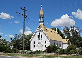
 St John's Lutheran church, Minyip | |
| Coordinates | 36°27′S 142°35′E / 36.450°S 142.583°E |
| Population | 82 (2016 census)[1] |
| Established | 1870s |
| Postcode(s) | 3392 |
| Location | |
| LGA(s) | Shire of Yarriambiack |
| State electorate(s) | Lowan |
| Federal division(s) | Mallee |
Minyip is a town in the Wimmera region of Victoria, Australia, 320 kilometres (199 mi) north west of Melbourne. It is in the Shire of Yarriambiack local government area. At the 2016 census, Minyip had a population of 524.[1]
The name "Minyip" is derived from an Aboriginal word for "ashes" or "camping place".[2][3]
The town is known as the "Heart of the Wheat Belt".[4] Dryland agriculture especially grain production and handling is one of the region's major industries.
- ^ a b Australian Bureau of Statistics (27 June 2017). "Minyip (State Suburb)". 2016 Census QuickStats. Retrieved 26 March 2018.
- ^ "Minyip". Victorian Places. Monash University and University of Queensland. Retrieved 27 April 2020.
- ^ "Home". Yarriambiack Shire.
- ^ "Minyip agricultural show ceases after 102 years - Australasian Leisure Management". www.ausleisure.com.au.

