Back ميشاواكا Arabic ميشاواكا ARZ میشواکا، ایندیانا AZB Mishawaka Catalan Мишавака (Индиана) CE Mishawaka CEB Mishawaka, Indiana Welsh Mishawaka DAG Mishawaka German Mishawaka Spanish
Mishawaka, Indiana | |
|---|---|
| City of Mishawaka | |
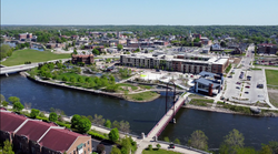
 Mishawaka downtown, south of the St. Joe River | |
| Nicknames: The Princess City, The Waka | |
 Location of Mishawaka in St. Joseph County, Indiana. | |
| Coordinates: 41°39′15″N 86°09′48″W / 41.65417°N 86.16333°W | |
| Country | United States |
| State | Indiana |
| County | St. Joseph |
| Township | Penn |
| Government | |
| • Mayor | Dave Wood (R)[1] [2] |
| Area | |
| • Total | 18.25 sq mi (47.26 km2) |
| • Land | 17.90 sq mi (46.35 km2) |
| • Water | 0.35 sq mi (0.90 km2) |
| Elevation | 738 ft (225 m) |
| Population (2020) | |
| • Total | 51,063 |
| • Density | 2,853.16/sq mi (1,101.61/km2) |
| Time zone | UTC−5 (EST) |
| • Summer (DST) | UTC−4 (EDT) |
| ZIP codes | 46544-46546 |
| Area code | 574 |
| FIPS code | 18-49932[5] |
| GNIS feature ID | 2395354[4] |
| Website | http://www.mishawaka.in.gov |
Mishawaka (/ˌmɪʃəˈwɑːkə/) is a city on the St. Joseph River, in Penn Township, St. Joseph County, in the U.S. state of Indiana.[6] The population was 51,063 as of the 2020 census. Its nickname is "the Princess City" or simply "The Waka". Mishawaka is a principal city of the South Bend-Mishawaka, Indiana — Michigan, Metropolitan Statistical Area.
- ^ "2023 St. Joseph County Election Results | South Bend Tribune".
- ^ "Office of the Mayor".
- ^ "2020 U.S. Gazetteer Files". United States Census Bureau. Retrieved March 16, 2022.
- ^ a b U.S. Geological Survey Geographic Names Information System: Mishawaka, Indiana
- ^ "U.S. Census website". United States Census Bureau. Retrieved January 31, 2008.
- ^ "Mishawaka, Indiana". Geographic Names Information System. United States Geological Survey, United States Department of the Interior. Retrieved November 5, 2016.

