Mission Bay | |
|---|---|
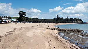
 View of Mission Bay Beach | |
 | |
| Coordinates: 36°50′53″S 174°49′50″E / 36.84817°S 174.83059°E | |
| Country | New Zealand |
| City | Auckland |
| Local authority | Auckland Council |
| Electoral ward | Ōrākei ward |
| Local board | Ōrākei Local Board |
| Area | |
| • Land | 154 ha (381 acres) |
| Population (June 2024)[2] | |
| • Total | 4,590 |
| Waitematā Harbour, Devonport | Hauraki Gulf | Rangitoto Island |
| Okahu Bay |
|
Kohimarama, Saint Heliers, Glendowie |
| Ōrākei | Meadowbank | Kohimarama, St Johns |
Mission Bay is a seaside suburb of Auckland city, on the North Island of New Zealand. The suburb's beach is a popular resort, located alongside Tamaki Drive.[3] The area also has a wide range of eateries. Mission Bay is located seven kilometres to the east of the city centre, on the southern shore of the Waitematā Harbour, between Ōrākei and Kohimarama. It covers an area of 1.08 km2 (267 acres), about three quarters of which comprises low hills, surrounding the remaining quarter, which slopes down to the sea. Local government of Mission Bay is the responsibility of the Ōrākei Local Board, which also includes the suburbs of Ōrākei, Kohimarama, St Heliers, Glendowie, St Johns, Meadowbank, Remuera and Ellerslie.
- ^ Cite error: The named reference
Areawas invoked but never defined (see the help page). - ^ "Aotearoa Data Explorer". Statistics New Zealand. Retrieved 26 October 2024.
- ^ Elizabeth T. Jackson (1976). Delving Into The Past of Auckland’s Eastern Suburbs: Section 4 Mission bay, Section 5 Kohimarama. Auckland, N.Z.
