Back ميوتا ARZ Miyota-machi CEB Miyota Spanish میوتا، ناگانو Persian Miyota Finnish Miyota French Միյոտա Armenian Miyota Italian 御代田町 Japanese 미요타정 Korean
Miyota
御代田 | |
|---|---|
 Miyota Town Hall | |
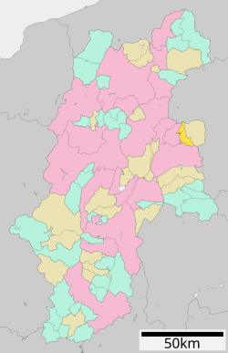
 Location of Miyota in Nagano Prefecture | |
| Coordinates: 36°19′16.3″N 138°30′31.6″E / 36.321194°N 138.508778°E | |
| Country | Japan |
| Region | Chūbu (Kōshin'etsu) |
| Prefecture | Nagano |
| District | Kitasaku |
| Area | |
| • Total | 58.76 km2 (22.69 sq mi) |
| Population (April 2019) | |
| • Total | 15,562 |
| • Density | 260/km2 (690/sq mi) |
| Time zone | UTC+9 (Japan Standard Time) |
| Symbols | |
| • Tree | Taxus cuspidata |
| • Flower | Lilium auratum |
| Phone number | 0267-32-3111 |
| Address | 2464-1 Miyota, Miyota-machi, Kitasaku-gun, Nagano-ken 389-0292 |
| Website | Official website |

Miyota (御代田町, Miyota-machi) is a town located in Nagano Prefecture, Japan. As of 1 April 2019[update], the town had an estimated population of 15,562 in 6897 households,[1] and a population density of 260 persons per km2. The total area of the town is 58.79 square kilometres (22.70 sq mi).
- ^ Miyota town official statistics(in Japanese)


