| Mneme Lake | |
|---|---|
| Location | Livingston Island, Antarctica |
| Coordinates | 62°35′40.7″S 60°54′30″W / 62.594639°S 60.90833°W |
| Lake type | Glacial lake |
| Max. length | 220 metres (720 ft) |
| Max. width | 85 metres (279 ft) |
| Surface area | 1.3 hectares (3.2 acres) |


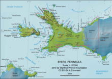
Mneme Lake (Bulgarian: езеро Мнема, romanized: ezero Mnema, IPA: [ˈɛzɛro ˈmnɛmɐ]) is the oval-shaped 220 m long in southwest–northeast direction and 85 m wide lake on the northwest coast of Livingston Island in the South Shetland Islands, Antarctica. It has a surface area of 1.3 ha and is separated from the waters of Barclay Bay by a 12 to 40 m wide strip of land. The lake and its vicinity lie in a restricted zone of scientific importance to Antarctic microbiology, part of the Antarctic Specially Protected Area Byers Peninsula.[1]
The feature is named after Mneme, the nymph of memory in Greek mythology.[1]
- ^ a b Mneme Lake. SCAR Composite Gazetteer of Antarctica

