Back Monroe Township (Gloucester County, New Jersey) German Municipio de Monroe (condado de Gloucester) Spanish ناحیه مونرو، شهرستان گلاستر، نیوجرسی Persian Monroe Township (comté de Gloucester, New Jersey) French Monroe, New Jersey HT Монро Тауншип (округ Глостер, Нью-Джерсі) Ukrainian
Monroe Township, New Jersey | |
|---|---|
 Downer Methodist Episcopal Church in Monroe Township, November 2011 | |
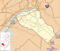
 Location of Monroe Township in Gloucester County highlighted in red (right). Inset map: Location of Gloucester County in New Jersey highlighted in red (left). | |
 Census Bureau map of Monroe Township, Gloucester County, New Jersey | |
Location in Gloucester County Location in New Jersey | |
| Coordinates: 39°39′37″N 74°58′09″W / 39.660224°N 74.969195°W[1][2] | |
| Country | |
| State | |
| County | |
| Incorporated | March 3, 1859 |
| Named for | President James Monroe |
| Government | |
| • Type | Faulkner Act (mayor–council) |
| • Body | Township Council |
| • Mayor | Gregory A. Wolfe (D, term ends December 31, 2026)[3][4] |
| • Administrator | Jill McCrea[5] |
| • Municipal clerk | Aileen Chiselko[6] |
| Area | |
| • Total | 46.93 sq mi (121.54 km2) |
| • Land | 46.42 sq mi (120.23 km2) |
| • Water | 0.51 sq mi (1.31 km2) 1.08% |
| • Rank | 36th of 565 in state 2nd of 24 in county[1] |
| Elevation | 121 ft (37 m) |
| Population | |
| • Total | 37,117 |
| • Estimate | 37,752 |
| • Rank | 65th of 565 in state 2nd of 24 in county[12] |
| • Density | 799.6/sq mi (308.7/km2) |
| • Rank | 408th of 565 in state 17th of 24 in county[12] |
| Time zone | UTC−05:00 (Eastern (EST)) |
| • Summer (DST) | UTC−04:00 (Eastern (EDT)) |
| ZIP Code | 08094 – Williamstown[13] |
| Area code(s) | 609 and 856[14] |
| FIPS code | 3401547250[1][15][16] |
| GNIS feature ID | 0882137[1][17] |
| Website | www |
Monroe Township is a township in Gloucester County, in the U.S. state of New Jersey. As of the 2020 United States census, the township's population was 37,117,[9][10] its highest decennial count ever and an increase of 988 (+2.7%) from the 36,129 recorded at the 2010 census,[18][19] which in turn reflected an increase of 7,162 (+24.7%) from the 28,967 counted in the 2000 census.[20] The township is part of the South Jersey region of the state and a suburb of Philadelphia, within the Delaware Valley.
Monroe Township was originally formed as a township by an act of the New Jersey Legislature on March 3, 1859, from portions of Washington Township while the area was still part of Camden County. Monroe Township was shifted to Gloucester County on February 28, 1871, along with the majority of Washington Township. In 1950, portions of the township were transferred to Winslow Township in Camden County.[21] The township was named for President James Monroe.[22]
- ^ a b c d e 2019 Census Gazetteer Files: New Jersey Places, United States Census Bureau. Accessed July 1, 2020.
- ^ US Gazetteer files: 2010, 2000, and 1990, United States Census Bureau. Accessed September 4, 2014.
- ^ Cite error: The named reference
Mayorwas invoked but never defined (see the help page). - ^ 2023 New Jersey Mayors Directory, New Jersey Department of Community Affairs, updated February 8, 2023. Accessed February 10, 2023.
- ^ Business Administrator, Township of Monroe. Accessed March 7, 2022.
- ^ Township Clerk, Township of Monroe. Accessed March 7, 2022.
- ^ Cite error: The named reference
DataBookwas invoked but never defined (see the help page). - ^ U.S. Geological Survey Geographic Names Information System: Township of Monroe, Geographic Names Information System. Accessed March 8, 2013.
- ^ a b c Cite error: The named reference
Census2020was invoked but never defined (see the help page). - ^ a b Cite error: The named reference
LWD2020was invoked but never defined (see the help page). - ^ Cite error: The named reference
PopEstwas invoked but never defined (see the help page). - ^ a b Population Density by County and Municipality: New Jersey, 2020 and 2021, New Jersey Department of Labor and Workforce Development. Accessed March 1, 2023.
- ^ Look Up a ZIP Code for Williamstown, NJ, United States Postal Service. Accessed November 7, 2012.
- ^ Area Code Lookup - NPA NXX for Williamstown, NJ, Area-Codes.com. Accessed October 22, 2013.
- ^ U.S. Census website, United States Census Bureau. Accessed September 4, 2014.
- ^ Geographic Codes Lookup for New Jersey, Missouri Census Data Center. Accessed April 1, 2022.
- ^ US Board on Geographic Names, United States Geological Survey. Accessed September 4, 2014.
- ^ Cite error: The named reference
Census2010was invoked but never defined (see the help page). - ^ Cite error: The named reference
LWD2010was invoked but never defined (see the help page). - ^ Table 7. Population for the Counties and Municipalities in New Jersey: 1990, 2000 and 2010, New Jersey Department of Labor and Workforce Development, February 2011. Accessed May 1, 2023.
- ^ Snyder, John P. The Story of New Jersey's Civil Boundaries: 1606-1968, Bureau of Geology and Topography; Trenton, New Jersey; 1969. p. 139. Accessed May 30, 2024.
- ^ Hutchinson, Viola L. The Origin of New Jersey Place Names, New Jersey Public Library Commission, May 1945. Accessed September 7, 2015.


