| Mont Albert Melbourne, Victoria | |||||||||||||||
|---|---|---|---|---|---|---|---|---|---|---|---|---|---|---|---|
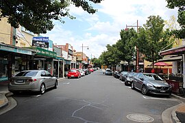
 Hamilton Street | |||||||||||||||
 | |||||||||||||||
| Coordinates | 37°48′58″S 145°6′36″E / 37.81611°S 145.11000°E | ||||||||||||||
| Population | 4,948 (SAL 2021)[1] | ||||||||||||||
| Postcode(s) | 3127 | ||||||||||||||
| Area | 1.6 km2 (0.6 sq mi) | ||||||||||||||
| Location | 12 km (7 mi) from Melbourne | ||||||||||||||
| LGA(s) | |||||||||||||||
| State electorate(s) | |||||||||||||||
| Federal division(s) | Kooyong | ||||||||||||||
| |||||||||||||||
Mont Albert is an inner eastern suburb of Melbourne, Victoria, Australia, 12 kilometres east of Melbourne's Central Business District,[2] located within the Cities of Boroondara and Whitehorse local government areas. Mont Albert recorded a population of 4,948 at the 2021 census.[3]
The main shopping centre of Mont Albert is Hamilton Street, a small street lined with shops. The suburb had its own railway station before being demolished as part of the Level Crossing Removal Project.
- ^ Australian Bureau of Statistics (28 June 2022). "Mont Albert (suburb and locality)". Australian Census 2021 QuickStats. Retrieved 28 June 2022.
- ^ "Postcode for Mont Albert, Victoria (Near Melbourne) - Postcodes Australia".
- ^ "2021 Census QuickStats Mont Albert". Australian Bureau of Statistics. Retrieved 3 July 2022.

