Back مقاطعة مونتغومري (جورجيا) Arabic Montgomery County, Georgia BAR Монтгомъри (окръг, Джорджия) Bulgarian মোন্টগোমেরী কাউন্টি, জর্জিয়া BPY Montgomery Gông (Georgia) CDO Монтгомери (гуо, Джорджи) CE Montgomery County (kondado sa Tinipong Bansa, Georgia) CEB Montgomery County, Georgia Welsh Montgomery County (Georgia) German Κομητεία Μοντγκόμερι (Τζόρτζια) Greek
Montgomery County | |
|---|---|
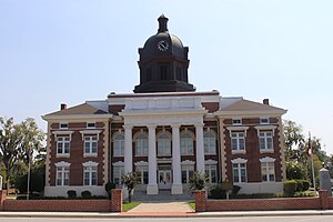
 Montgomery County Courthouse (built 1907) in Mount Vernon | |
 Location within the U.S. state of Georgia | |
 Georgia's location within the U.S. | |
| Coordinates: 32°10′N 82°32′W / 32.17°N 82.53°W | |
| Country | |
| State | |
| Founded | December 19, 1793 |
| Named for | Richard Montgomery |
| Seat | Mount Vernon |
| Largest city | Mount Vernon |
| Area | |
| • Total | 245 sq mi (630 km2) |
| • Land | 240 sq mi (600 km2) |
| • Water | 5.2 sq mi (13 km2) 2.1% |
| Population (2020) | |
| • Total | 8,610 |
| • Density | 36/sq mi (14/km2) |
| Time zone | UTC−5 (Eastern) |
| • Summer (DST) | UTC−4 (EDT) |
| Congressional district | 12th |
| Website | montgomerycountyga |
Montgomery County is a county located in the central portion of the U.S. state of Georgia. As of the 2020 census, the population was 8,610.[1] The county seat is Mount Vernon.[2] Montgomery County is part of the Vidalia, GA micropolitan statistical area.
- ^ "Census - Geography Profile: Montgomery County, Georgia". United States Census Bureau. Retrieved December 27, 2022.
- ^ "Find a County". National Association of Counties. Retrieved June 7, 2011.