Back مونتروس (فيرجينيا) Arabic Montross Catalan Монтросс (Виргини) CE Montross CEB Montross, Virginia Welsh Montross (Virginia) Spanish Montross (Virginia) Basque Montross (Virginie) French Montross, Vijini HT Montross (Virginia) Hungarian
Montross, Virginia | |
|---|---|
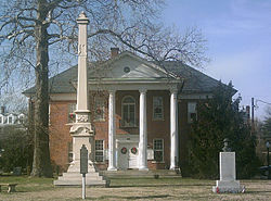
 Courthouse in Montross, with historic marker in foreground | |
 Location of Montross, Virginia | |
| Coordinates: 38°5′38″N 76°49′34″W / 38.09389°N 76.82611°W | |
| Country | United States |
| State | Virginia |
| County | Westmoreland |
| Area | |
| • Total | 1.03 sq mi (2.67 km2) |
| • Land | 1.03 sq mi (2.67 km2) |
| • Water | 0.00 sq mi (0.00 km2) |
| Elevation | 164 ft (50 m) |
| Population (2022) | |
| • Total | 553 |
| • Density | 536.6/sq mi (146.11/km2) |
| Time zone | UTC−5 (Eastern (EST)) |
| • Summer (DST) | UTC−4 (EDT) |
| ZIP code | 22520 |
| Area code | 804 |
| FIPS code | 51-52952[2] |
| GNIS feature ID | 1498518[3] |
| Website | https://www.townofmontross.org |
Montross is a town in Westmoreland County, Virginia, United States. The population was 553 at the 2020 census.[4] It is the county seat of Westmoreland County.[5] Located in the historic Northern Neck of Virginia, Montross is near the George Washington Birthplace National Monument and the Stratford Hall Plantation (the birthplace of Robert E. Lee and Founding Fathers and signers of the Declaration of Independence, Richard Henry Lee and Francis Lightfoot Lee). The town's slogan is return to the village.
- ^ "2019 U.S. Gazetteer Files". United States Census Bureau. Retrieved August 7, 2020.
- ^ "U.S. Census website". United States Census Bureau. Retrieved January 31, 2008.
- ^ "US Board on Geographic Names". United States Geological Survey. October 25, 2007. Retrieved January 31, 2008.
- ^ "Census profile: Montross, VA". Census Reporter. Retrieved June 30, 2022.
- ^ "How much do you know about your county?". County Explorer. Retrieved June 30, 2022.