Back Moorefield Township (Clark County, Ohio) German Municipio de Moorefield (condado de Clark) Spanish Moorefield udalerria, Clark konderria (Ohio) Basque بخش مورفیلد، شهرستان کلارک، اوهایو Persian Município de Moorefield (condado de Clark, Ohio) Portuguese Xã Moorefield, Quận Clark, Ohio Vietnamese
Moorefield Township, Clark County, Ohio | |
|---|---|
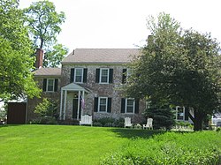
 The Kenton-Hunt Farm, a historic site in the township | |
 Location of Moorefield Township in Clark County | |
| Coordinates: 39°59′0″N 83°46′3″W / 39.98333°N 83.76750°W | |
| Country | United States |
| State | Ohio |
| County | Clark |
| Area | |
| • Total | 33.0 sq mi (85.5 km2) |
| • Land | 29.9 sq mi (77.4 km2) |
| • Water | 3.1 sq mi (8.1 km2) |
| Elevation | 1,099 ft (335 m) |
| Population | |
| • Total | 12,622 |
| • Density | 380/sq mi (150/km2) |
| Time zone | UTC-5 (Eastern (EST)) |
| • Summer (DST) | UTC-4 (EDT) |
| FIPS code | 39-51912[3] |
| GNIS feature ID | 1085856[1] |
| Website | moorefieldtownship |
Moorefield Township is one of the ten townships of Clark County, Ohio, United States. The population as of the 2020 census was 12,622.
- ^ a b "US Board on Geographic Names". United States Geological Survey. October 25, 2007. Retrieved January 31, 2008.
- ^ "Moorefield township, Clark County, Ohio". United States Census Bureau. Retrieved May 31, 2023.
- ^ "U.S. Census website". United States Census Bureau. Retrieved January 31, 2008.