Mott Haven | |
|---|---|
 East 139th Street, between Willis and Brook Avenues, facing east | |
| Nickname: "The Boogie Down Bronx" | |
 Location in New York City | |
| Coordinates: 40°48′36″N 73°55′34″W / 40.81°N 73.926°W | |
| Country | |
| State | |
| City | |
| Borough | |
| Community District | Bronx 1[2] |
| Founded | 1849 |
| Named for | Jordan Lawrence Mott |
| Area | |
| • Total | 3.06 km2 (1.180 sq mi) |
| Population (2020)[4] | |
| • Total | 54,163[1] |
| Economics | |
| • Median income | $25,325 |
| Ethnicity | |
| • Hispanic | 68.8% |
| • Black | 28% |
| • White | 1.9% |
| • Asian | 0.4% |
| • Other | 0.9% |
| ZIP Codes | 10451, 10454, 10455 |
| Area codes | 718, 347, 929, and 917 |
| Website | www |
Mott Haven Historic District | |
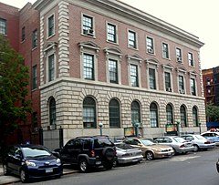
 40th Precinct Police Station, July 2010 | |
| Location | An irregular pattern along Alexander Ave. and E. 138th St., New York, New York |
| Area | 11 acres (4.5 ha) |
| Built | 1850 |
| Architect | Multiple |
| Architectural style | Gothic, Queen Anne, Romanesque |
| NRHP reference No. | 80002586[6] |
| Added to NRHP | March 25, 1980 |
Mott Haven is a primarily residential neighborhood in the southwestern section of the New York City borough of the Bronx. It is generally bounded by East 149th Street to the north, the Bruckner Expressway to the east and south, and the Harlem River to the west,[7] although these boundaries are not precise.[8][9][10] East 138th Street is the primary east–west thoroughfare through Mott Haven.
The neighborhood is part of Bronx Community Board 1, and is located within ZIP Codes 10451, 10454, and 10455.[11] Mott Haven is patrolled by the New York City Police Department's 40th Precinct.[12]
The local subway line is the IRT Pelham Line (6 and <6> trains), operating along East 138th Street. The local buses are the Bx1, Bx2, Bx17, Bx19, Bx21, Bx32, Bx33, M125. Mott Haven is served by the Triborough Bridge, the Third Avenue Bridge, the Madison Avenue Bridge, the 145th Street Bridge, and the Willis Avenue Bridge. The closest Metro-North Railroad stops are Harlem – 125th Street and Yankees – East 153rd Street.
- ^ Demographics by Neighborhood Tabulation Area (NTA) Archived March 31, 2023, at the Wayback Machine, New York City Department for the Aging, November 2020. Accessed February 28, 2023.
- ^ "NYC Planning | Community Profiles". communityprofiles.planning.nyc.gov. New York City Department of City Planning. Retrieved February 25, 2018.
- ^ "Mott Haven neighborhood in New York". Retrieved June 4, 2014.
- ^ Cite error: The named reference
PLP5was invoked but never defined (see the help page). - ^ Cite error: The named reference
PLP3Awas invoked but never defined (see the help page). - ^ "National Register Information System". National Register of Historic Places. National Park Service. March 13, 2009.
- ^ Hughes, C. J. (March 25, 2015). "Mott Haven, the Bronx, in Transition". The New York Times. ISSN 0362-4331. Retrieved December 27, 2023.
- ^ "Bronx Harlem River - DCP".
- ^ Small, Eddie. "MAP: Here is Where Readers Think South Bronx Neighborhoods Begin and End" Archived April 23, 2021, at the Wayback Machine, DNA Info, September 29, 2015. Retrieved January 24, 2022. "The maps have been drawn, and most DNAinfo readers agree that Mott Haven stretches from 135th Street to 149th Street — although those are far from universally agreed upon borders.... For instance, despite a general consensus that Mott Haven was bordered by 135th Street to the south and 149th Street to the north, some readers had the neighborhood occupying a much larger space, going from the borough's southern waterfront all the way up to 163rd Street to the north."
- ^ Port Morris/Bruckner Boulevard Rezoning - Approved!, New York City Department of City Planning. Retrieved January 24, 2022.
- ^ "Bronx Community District 1" (PDF). Archived from the original (PDF) on March 4, 2016. Retrieved September 21, 2015.
- ^ Cite error: The named reference
NYPD 40th Precinctwas invoked but never defined (see the help page).
