Back مقاطعة مولتري (إلينوي) Arabic Moultrie County, Illinois BAR Молтрий (окръг, Илинойс) Bulgarian মৌলট্রাই কাউন্টি, ইলিনয়স BPY Moultrie Gông (Illinois) CDO Молтри (гуо, Иллинойс) CE Moultrie County CEB Moultrie County, Illinois Welsh Moultrie County German Condado de Moultrie Spanish
Moultrie County | |
|---|---|
 Moultrie County Courthouse in Sullivan | |
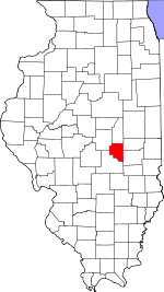
 Location within the U.S. state of Illinois | |
 Illinois's location within the U.S. | |
| Coordinates: 39°38′N 88°37′W / 39.64°N 88.62°W | |
| Country | |
| State | |
| Founded | February 16, 1843 |
| Named for | William Moultrie |
| Seat | Sullivan |
| Largest city | Sullivan |
| Area | |
| • Total | 344 sq mi (890 km2) |
| • Land | 336 sq mi (870 km2) |
| • Water | 8.5 sq mi (22 km2) 2.5% |
| Population (2020) | |
| • Total | 14,526 |
| • Estimate (2021)[1] | 14,510 |
| • Density | 42/sq mi (16/km2) |
| Time zone | UTC−6 (Central) |
| • Summer (DST) | UTC−5 (CDT) |
| Congressional district | 15th |
| Website | www |
Moultrie County is a county in the U.S. state of Illinois. According to the 2020 United States Census, its population was 14,526.[2] Its county seat is Sullivan.[3] The name is pronounced as in "mole tree", unlike the pronunciation of its namesake, the South Carolinian Revolutionary War hero William Moultrie.
- ^ "QuickFacts: Moultrie County, Illinois". Census.gov. Retrieved May 24, 2022.
- ^ Cite error: The named reference
new-censuswas invoked but never defined (see the help page). - ^ "Find a County". National Association of Counties. Retrieved June 7, 2011.
