Back Ararat Afrikaans Ararat ALS ደብረ አራራት Amharic جبل أرارات Arabic جبل ارارات ARZ Monte Arará AST Ağrı dağı Azerbaijani آغری داغی AZB Арарат Bashkir Арарат Byelorussian
| Mount Ararat | |
|---|---|
| Highest point | |
| Elevation | 5,137 m (16,854 ft) See Elevation section |
| Prominence | 3,611 m (11,847 ft)[1] Ranked 48th |
| Isolation | 379.29 km (235.68 mi) |
| Listing | Country high point Ultra Volcanic Seven Second Summits |
| Coordinates | 39°42′07″N 44°17′54″E / 39.7019°N 44.2983°E[2] |
| Naming | |
| Native name | |
| Geography | |
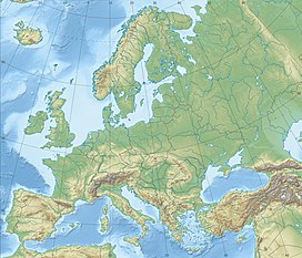
| Location | Iğdır and Ağrı provinces, Turkey |
| Region | Eastern Anatolia Region |
| Parent range | Armenian Highlands |
| Geology | |
| Mountain type | Stratovolcano |
| Last eruption | July 2, 1840 |
| Climbing | |
| First ascent | 9 October [O.S. 27 September] 1829 Friedrich Parrot, Khachatur Abovian, two Russian soldiers, two Armenian villagers |
| Designations | |
|---|---|
IUCN Category II (National Park) | |
| Official name | Ağrı Dağı Milli Parkı |
| Designated | 1 November 2004[3] |
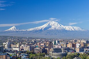
Mount Ararat[a] (/ˈærəræt/, ARR-ə-rat; Armenian: Արարատ, romanized: Ararat [ɑɾɑˈɾɑt] ) or Mount Ağrı (Turkish: Ağrı Dağı; Kurdish: Çiyayê Agirî)[4][5] is a snow-capped and dormant compound volcano in Eastern Turkey. It consists of two major volcanic cones: Greater Ararat and Little Ararat. Greater Ararat is the highest peak in Turkey; Little Ararat's elevation is 3,896 m (12,782 ft).[6] The Ararat massif is about 35 km (22 mi) wide at ground base.[7] The first recorded efforts to reach Ararat's summit were made in the Middle Ages, and Friedrich Parrot, Khachatur Abovian, and four others made the first recorded ascent in 1829.
In Europe, the mountain has been called by the name Ararat since the Middle Ages, as it began to be identified with "mountains of Ararat" described in the Bible as the resting-place of Noah's Ark, despite contention that Genesis 8:4 does not refer specifically to a Mount Ararat.
Although lying outside the borders of modern Armenia, the mountain is the principal national symbol of Armenia and has been considered a sacred mountain by Armenians. It has featured prominently in Armenian literature and art and is an icon for Armenian irredentism. It is depicted on the coat of arms of Armenia along with Noah's Ark.
- ^ "100 World Mountains ranked by primary factor". ii.uib.no. Institutt for informatikk University of Bergen. Archived from the original on 2016-05-21. Retrieved 2016-05-09.
- ^ "Topographic map of Ağrı Dağı". opentopomap.org. Retrieved 2023-06-13.
- ^ "Ağrı Dağı Milli Parkı [Ağrı Dağı National Park]". ormansu.gov.tr (in Turkish). Republic of Turkey Ministry of Forest and Water Management. Archived from the original on 2016-05-05. Retrieved 2016-04-11.
- ^ Cite error: The named reference
:0was invoked but never defined (see the help page). - ^ "Ağri Daği (the so-called Ararat) - Livius". www.livius.org. Retrieved 2024-07-20.
- ^ Yilmaz, Y.; Güner, Y.; Saroğlu, F. (1998). "Geology of the quaternary volcanic centres of the east Anatolia". Journal of Volcanology and Geothermal Research. 85 (1–4): 173–210. Bibcode:1998JVGR...85..173Y. doi:10.1016/s0377-0273(98)00055-9. ISSN 0377-0273.
- ^ Short, Nicholas M.; Blair, Robert W., eds. (1986). "Mt. Ararat, Turkey". Geomorphology From Space: A Global Overview of Regional Landforms. National Aeronautics and Space Administration. p. 226.
Cite error: There are <ref group=lower-alpha> tags or {{efn}} templates on this page, but the references will not show without a {{reflist|group=lower-alpha}} template or {{notelist}} template (see the help page).


