| Mount Carmel National Park | |
|---|---|
| פארק הכרמל | |
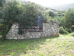
 The entrance to the park on Road 7212 near the town of Nesher | |
 | |
| Type | National park, biosphere reserve |
| Location | Carmel mountain range, Israel |
| Coordinates | 32°45′19″N 35°00′09″E / 32.7554°N 35.0024°E |
| Area | 10,000 hectares |
| Established | 1960 |
| Operated by | Israel Nature and Parks Authority |
| Status | Open to public |
Mount Carmel National Park (Hebrew: פארק הכרמל, Park HaKarmel) is Israel's largest national park, extending over most of the Carmel mountain range and containing over 10,000 hectares of pine, eucalyptus, and cypress forest. The park has numerous bicycle and walking paths, dedicated nature reserves, and over 250 archaeological sites of prehistoric human habitations.
The park is one of the largest open spaces of northern Israel. It is a typical example of a Mediterranean ecosystem and includes a rich inventory of geological phenomena, prehistoric artifacts, biodiversity and landscapes. In 1996 it was recognized by UNESCO as a biosphere reserve.[1]
- ^ "UNESCO - MAB Biosphere Reserves Directory". www.unesco.org. Retrieved 2016-07-17.
