Back جبل مونت ايساروج ARZ Bukid Isarog BCL Mount Isarog CEB Isarog Czech Mynydd Isarog Welsh Isarog German Monte Isarog Spanish کوه ایساروگ Persian Mont Isarog French Bantay Isarog ILO
| Mount Isarog | |
|---|---|
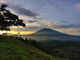
 Mt. Isarog viewed from Baao, Camarines Sur | |
| Highest point | |
| Elevation | 2,011.6 m (6,600 ft)[1][2] |
| Prominence | 1,951 m (6,401 ft)[1] |
| Parent peak | Mayon |
| Listing | |
| Coordinates | 13°39′33″N 123°22′24″E / 13.65917°N 123.37333°E[1][3] |
| Geography | |
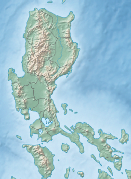
Location in Luzon | |
 | |
| Country | Philippines |
| Region | Bicol Region |
| Province | Camarines Sur |
| City/municipality | |
| Geology | |
| Mountain type | Stratovolcano |
| Volcanic arc/belt | Bicol Volcanic Chain |
| Last eruption | 2,374 BCE ± 87 years [4] 3,500 BCE ± 125 years (5,500 ya ± 125 years)[5] |
| Climbing | |
| Easiest route | Concosep, Tigaon, Camarines Sur Route |
Mount Isarog is an active[6] stratovolcano located in the province of Camarines Sur, Philippines, on the island of Luzon. The mountain has active fumaroles and hot springs.[7][8] It has an elevation of 2,011.6 m (6,600 ft) above mean sea level.[9]
The broad isthmus between Lagonoy Gulf and San Miguel Bay is occupied by the isolated Mount Isarog volcano.
The volcano has a 2,500 m (8202 ft) crater that is breached to the east along a narrow valley drained by the Cabongaan water stream. A major debris avalanche deposit extends northwest to the coast and into San Miguel Bay.[10]
The peak of the mountain marks the point where the borders of six municipalities and one city meet (listed in clockwise direction, starting north): Goa, Tigaon, Ocampo, Pili, Naga City, Tinambac and Calabanga.
Mount Isarog was where local troops of the Philippine Army and Constabulary units and Bicolano guerrillas hid during the Japanese Occupation. In the 1970s, with the leadership of Romulo Jallores and his brother, they established the New People's Army in the Bicol region at the foot of this mountain.[9]
- ^ a b c "Philippines Mountains" - Ultra Prominence Page. Peaklist.org. Retrieved March 30, 2012.
- ^ "Mount Isarog, Philippines". Peakbagger.com. Retrieved March 30, 2012.
- ^ "Isarog". Global Volcanism Program. Smithsonian Institution. Retrieved July 30, 2020.
- ^ Jonas Cabiles Soltes. "It is official: Mt. Isarog is active".
- ^ Smithsonian Institution. "Isarog". Retrieved June 16, 2021.
- ^ Philippine Institute of Volcanology and Seismology (2018). "Volcanoes of the Philippines".
- ^ Awakening of two old volcanoes in Luzon, Philippine Islands. v. 6. Bulletin of the Seismological Society of America. December 1916. pp. 236–240.
- ^ "Isarog". www.volcanodiscovery.com. Retrieved January 5, 2021.
- ^ a b Gerona, Danillo (June–July 1993) [1993]. "Isarog Through the Years". The Bikol Executive. Vol. 1. pp. 21–22.
- ^ "Global Volcanism Program | Isarog". Smithsonian Institution | Global Volcanism Program. Retrieved January 22, 2021.

