Back Mount Kaputar National Park CEB Mount-Kaputar-Nationalpark German Parque nacional Monte Kaputar Spanish Parc national du Mont Kaputar French Nationaal park Mount Kaputar Dutch Маунт Капјутар (национални парк) Serbian Mount Kaputar National Park Swedish Vườn quốc gia núi Kaputar Vietnamese
| Mount Kaputar National Park New South Wales | |
|---|---|
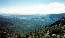
 View of the park from the top of Mount Kaputar, oriented approximately west | |
| Coordinates | 30°17′26″S 150°08′34″E / 30.29056°S 150.14278°E |
| Area | 502.25 [1] |
| Managing authorities |
|
| Footnotes | Managing Authorities[2] |
| See also | Protected areas of New South Wales |
The Mount Kaputar National Park is a national park located in New South Wales, Australia, surrounding the proximities of Mount Kaputar, a volcano active between 17 and 21 million years ago.[3] It is located 50 km (31 mi) east of Narrabri and 570 km (354 mi) northwest of Sydney.[4] Millions of years of erosion have since carved the volcanic region into the lava terraces, volcanic plugs, and dykes of Nandewar Range. The central feature of the region is Mount Kaputar, the park's namesake, which rises to an altitude of 1,510 m (4,954 ft).[3] The 360 degree view from the summit of the mountain encompasses one-tenth of New South Wales' area or 80,000 square kilometres (31,000 sq mi).[4]
The park protects a wide range of biomes, including semi-arid woodland, subalpine heath, and eucalypt forests, and provides a habitat for a range of animals, including bats, birds, wallabies, quolls, and the unique red triangle slug (Triboniophorus graeffei), which is known to appear after rainfall.[3]
- ^ "Mount Kaputar National Park Plan of Management" (PDF). Retrieved 31 January 2023.
- ^ Cite error: The named reference
park-histwas invoked but never defined (see the help page). - ^ a b c "Mount Kaputar National Park". Retrieved 27 December 2009.
- ^ a b "Mount Kaputar National Park Information". Pleasetakemeto.com. Archived from the original on 31 January 2013. Retrieved 27 December 2009.
