Back Mount Kosciuszko Afrikaans جبل كوسيياسكو Arabic جبل كوسيياسكو ARZ Monte Kosciuszko AST Kostyuşko (dağ) Azerbaijani Косцюшко (тау) Bashkir Касцюшка (гара) Byelorussian Касьцюшка (гара) BE-X-OLD Косцюшко (връх) Bulgarian माउंट कोज़ीओस्को Bihari
| Mount Kosciuszko | |
|---|---|
| Tar-gan-gil/Kunama Namadgi | |
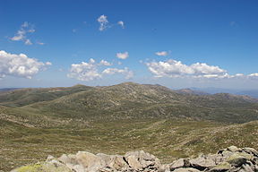
 Mount Kosciuszko as viewed from Mount Townsend (the second highest peak in Mainland Australia), Kosciuszko National Park | |
| Highest point | |
| Elevation | 2,228 m (7,310 ft)[1][2] |
| Prominence | 2,228 m (7,310 ft)[1] |
| Isolation | 1,894.26 km (1,177.04 mi)[1] |
| Listing | |
| Coordinates | 36°27′21″S 148°15′49″E / 36.45583°S 148.26361°E[3] |
| Geography | |
| Parent range | Main Range, Great Dividing Range |
| Topo map | Perisher Valley |
| Climbing | |
| Easiest route | Walk (dirt road) |
Mount Kosciuszko (/ˌkɒziˈʌskoʊ/ KOZ-ee-USK-oh;[4] Ngarigo: Kunama Namadgi)[5][6] is mainland Australia's highest mountain, at 2,228 metres (7,310 ft) above sea level. It is located on the Main Range of the Snowy Mountains in Kosciuszko National Park, part of the Australian Alps National Parks and Reserves, in New South Wales, Australia, and is located west of Crackenback and close to Jindabyne, near the border with Victoria. Mount Kosciuszko is ranked 35th by topographic isolation.
- ^ a b c "Mountain Kosciuszko, Australia". Peakbagger.com. Retrieved 28 May 2015.
- ^ "Kosciuszko National Park". Australian Alps National Parks. Australian Government. Archived from the original on 7 January 2019. Retrieved 13 June 2009.
- ^ "Mount Kosciuszko". Geographical Names Register (GNR) of NSW. Geographical Names Board of New South Wales. Retrieved 27 May 2015.
- ^ Wells, John C. (2008). Longman Pronunciation Dictionary (3 ed.). Harlow: Pearson. p. 446. ISBN 978-1-4058-8118-0. "Kosciusko [sic]".
- ^ Andrews, Alan E. J. "Mount Kosciuszko - Our Highest Mountain". mtkosciuszko.org.au. Tabletop Press - ACT. Archived from the original on 5 October 2024. Retrieved 6 September 2020.
- ^ Wheaton, Claire; Lauder, Simon (14 June 2019). "Is it time to give Mount Kosciuszko a dual name?". www.abc.net.au. ABC. Archived from the original on 5 October 2024. Retrieved 6 September 2020.

