Back جبل مونت ناپير ARZ Mount Napier (bukid sa Ostralya, State of Victoria) CEB Mount Napier German Mont Napier French Sliabh Napier Irish Mount Napier LLD Mount Napier Swedish
| Mount Napier (Tapoc) | |
|---|---|
 Mount Napier/Tapoc, pictured in 2006. | |
| Highest point | |
| Elevation | 440 metres (1,440 ft) AHD |
| Prominence | 150 metres (490 ft) AHD |
| Listing | Volcanoes in Australia |
| Coordinates | 37°53′36″S 142°3′29″E / 37.89333°S 142.05806°E[1] |
| Geography | |
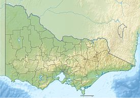
Location in Victoria | |
| Geology | |
| Volcanic arc/belt | Newer Volcanics Province |

Mount Napier in Victoria, Australia, is one of the youngest volcanoes in Australia.[2] It erupted about 32,000 years ago.[3] It was named by Major Thomas Mitchell after the three Napier brothers, who he had served alongside during the Peninsular War. Mitchell named it in August 1836, during his third expedition across south-eastern Australia. The local Aboriginal name for the mountain is Tapoc.[4] Mount Napier State Park is located 270 kilometres west of Melbourne and 17 km south of Hamilton.
- ^ "Mount Napier". Gazetteer of Australia online. Geoscience Australia, Australian Government.
- ^ "Mount Napier State Park". Parks Victoria. Retrieved 22 February 2022.
- ^ Grimes, Ken (2013). "The Ages of Our Volcanoes" (PDF). Archived from the original (PDF) on 8 August 2014. Retrieved 5 August 2014.
- ^ Frankel, David; Major, Janine (2014). Kulin and Kurnai : Victorian Aboriginal life and customs. p. 138. ISBN 978-1326124779.
