Back جبل مونت پيليون ياست ARZ Mount Pelion East CEB Mount Pelion East German Monte Pelion Est Italian Mount Pelion East LLD Mount Pelion East Polish Пелион-Ист Russian Mount Pelion East Swedish
| Mount Pelion East | |
|---|---|
 Mount Pelion East | |
| Highest point | |
| Elevation | 1,461 m (4,793 ft)[1][2] |
| Prominence | 335 m (1,099 ft)[2] |
| Parent peak | Mount Ossa |
| Isolation | 3.23 km (2.01 mi)[2] |
| Listing | 25th highest mountain in Tasmania |
| Coordinates | 41°51′00″S 146°03′36″E / 41.85000°S 146.06000°E[3] |
| Geography | |
Location in Tasmania | |
| Location | Central Highlands, Tasmania, Australia |
| Parent range | Pelion |
| Topo map | Tasmap Cathedral 1:25000 |
| Geology | |
| Age of rock | Jurassic |
| Mountain type | Dolerite |
| Climbing | |
| Easiest route | Walk / hike via the Overland Track from Pelion Gap |
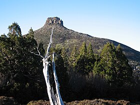
Mount Pelion East is a mountain located in the Central Highlands region of Tasmania, Australia. The mountain is situated within the Cradle Mountain-Lake St Clair National Park.
With an elevation of 1,461 metres (4,793 ft) above sea level, the mountain is the 25th highest mountain in Tasmania, slightly higher than the better known Frenchmans Cap at 1,446 metres (4,744 ft). Unlike Mount Pelion West, Pelion East is not a massive mountain, more pinnacle-like, the spire shape having been caused by harsh glacial erosion many thousands of years ago.
- ^ "LISTmap (Mount Pelion East)". Department of Primary Industries and Water. Government of Tasmania. Retrieved 29 February 2008.
- ^ a b c "Mount Pelion East, Australia". Peakbagger.com. Retrieved 7 June 2015.
- ^ "Mount Pelion East (TAS)". Gazetteer of Australia online. Geoscience Australia, Australian Government.
