Back جبل مونت روندل ARZ Menez Rundle Breton Mount Rundle CEB Mynydd Rundle Welsh Mount Rundle German Monte Rundle Spanish Mont Rundle French Mount Rundle LLD Mount Rundle Swedish
| Mount Rundle | |
|---|---|
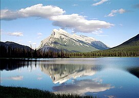
 Mount Rundle as seen from Vermilion Lakes | |
| Highest point | |
| Elevation | 2,948 m (9,672 ft)[1] |
| Prominence | 1,304 m (4,278 ft)[2] |
| Coordinates | 51°07′27″N 115°28′13″W / 51.12417°N 115.47028°W[2] |
| Naming | |
| Native name | Waskahigan Watchi (Cree) |
| Geography | |
Alberta, Canada | |
 | |
| Interactive map of Mount Rundle | |
| Parent range | Canadian Rockies (South Banff Ranges/Rundle Peaks) |
| Topo map | NTS 82O3 Canmore |
| Climbing | |
| First ascent | 1888 by J.J. McArthur |
| Easiest route | Scramble |
Mount Rundle is a mountain in Canada's Banff National Park overlooking the towns of Banff and Canmore, Alberta. The Cree name was Waskahigan Watchi or house mountain.[Notes 1][1][failed verification] In 1858 John Palliser renamed[1] the mountain after Reverend Robert Rundle, a Methodist invited by the Hudson's Bay Company to do missionary work in western Canada in the 1840s. He introduced syllabics there[Notes 2]—a written language developed for the Cree, as part of his missionary work.[3] He only visited the Stoney-Nakoda of the area around what is now called Mount Rundle in 1844 and 1847.[4]
Mt. Rundle could actually be considered a small mountain range as the mountain extends for over 12 kilometres (7.5 mi), on the south side of the Trans-Canada Highway eastward from Banff to Canmore with seven distinct peaks along the way.[2] The third peak southeast of Banff is the highest at 9,675 feet (2,949 m).[2][5] West of the Spray Lakes road is the East End of Rundle— locally known as EEOR[Notes 3]—which rises above Whiteman's Gap just south of Canmore. The Rundle Peaks are part of the South Banff Ranges, along with its siblings—the Sundance Range, Sulphur Mountain and the Goat Range.[5]
- ^ a b c "Mount Rundle". cdnrockiesdatabases.ca. Retrieved 11 September 2019.
- ^ a b c d "Mount Rundle". Bivouac.com. Retrieved 29 January 2014.
- ^ Rundle, Robert (1977), The Rundle Journals, Glenbow Institute
- ^ "Biography – RUNDLE, ROBERT TERRILL". biographi.ca. Volume XII (1891–1900). Dictionary of Canadian Biography. Retrieved 11 September 2019.
- ^ a b "Rundle Peaks". Peakbagger.com. Retrieved 29 January 2014.
Cite error: There are <ref group=Notes> tags on this page, but the references will not show without a {{reflist|group=Notes}} template (see the help page).
