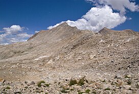
| Mount Warlow | |
|---|---|
 South aspect, from Muir Pass | |
| Highest point | |
| Elevation | 13,206 ft (4,025 m)[1] |
| Prominence | 526 ft (160 m)[1] |
| Parent peak | Mount Fiske (13,503 ft)[2] |
| Isolation | 0.68 mi (1.09 km)[2] |
| Coordinates | 37°07′42″N 118°40′29″W / 37.1284231°N 118.6747173°W[3] |
| Naming | |
| Etymology | Chester H. Warlow |
| Geography | |
| Location | Kings Canyon National Park Fresno County California, U.S. |
| Parent range | Sierra Nevada[1] |
| Topo map | USGS Mount Darwin |
| Geology | |
| Type of rock | granite |
| Climbing | |
| First ascent | 1926 |
| Easiest route | class 2[2] South Ridge |
Mount Warlow is a 13,206-foot-elevation (4,025 meter) mountain summit located 1.5 miles (2.4 km) west of the crest of the Sierra Nevada mountain range, in Fresno County of northern California, United States.[3] It is situated on the Goddard Divide in northern Kings Canyon National Park, 1.2 miles (1.9 km) north of Muir Pass, 0.69 miles (1.11 km) southeast of Mount Huxley, and 0.68 miles (1.09 km) southwest of Mount Fiske, which is the nearest higher neighbor. Mount Warlow ranks as the 108th highest summit in California.[2] The approach to this remote peak is made via the John Muir Trail.
- ^ a b c "Mount Warlow, California". Peakbagger.com. Retrieved 2021-04-17.
- ^ a b c d "Warlow, Mount - 13,206' CA". listsofjohn.com. Retrieved 2021-04-17.
- ^ a b "Mount Warlow". Geographic Names Information System. United States Geological Survey, United States Department of the Interior. Retrieved 2021-04-17.


